 Filter: Categories of Wisconsin Historical Images
Filter: County of Manitowoc
Filter: Creator Name of Unknown
Filter: Type of Map or Atlas
Filter: Categories of Wisconsin Historical Images
Filter: County of Manitowoc
Filter: Creator Name of Unknown
Filter: Type of Map or Atlas

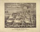
| Date: | 1868 |
|---|---|
| Description: | Bird's-eye map of Manitowoc, with four insets. Manitowoc County. |
| Date: | 1860 |
|---|---|
| Description: | Ansicht Von St Nanianz, gregundet vom Jahr 1854 bis 1860. Sr. Hochw. Hern V. Oschald. n.p., n.d. |

| Date: | 1800 |
|---|---|
| Description: | This 19th-century manuscript map of the Town of Newton, Manitowoc County, Wisconsin, shows sections, lakes and streams, the trail from Chicago to Green Bay... |

| Date: | 1964 |
|---|---|
| Description: | This map of Two Rivers shows the Rodgers street fishing area and land use. The map features a legend on the right of the types of land use. The map also sh... |

| Date: | 1856 |
|---|---|
| Description: | This map shows the Manitowoc River, Lake Michigan, streets, and buildings. Relief is shown by hachures and soundings are in feet and decimals of a foot. Th... |

| Date: | 09 1853 |
|---|---|
| Description: | This map shows streets, docks, warehouses, and piers near the harbor. The Manitowoc River and Lake Michigan are labeled. Depths are indicated by soundings ... |

| Date: | 1856 |
|---|---|
| Description: | This map shows streets, piers, and wharves. Lake Michigan, the Manitowoc River, and select buildings are labeled. Relief is shown by hachures and sounding... |

| Date: | 1865 |
|---|---|
| Description: | This map shows the river shore and piers. Lake Michigan is labeled. Depths are shown by soundings and isolines. The bottom margin includes notes on soundi... |

| Date: | 1874 |
|---|---|
| Description: | This map shows piers, streets, the Manitowoc River and shore lines of 1856, 1869, 1873 and 1874. The top margin reads; "Soundings taken 1974." Written in i... |

| Date: | 1903 |
|---|---|
| Description: | This map shows lakes, roads, railroads, townships, and land ownership by name. Counties are colored red, blue, or yellow. Lake Michigan is labeled. Also in... |

| Date: | 1870 |
|---|---|
| Description: | This blueprint map shows lot and block numbers, streets, and right of way for the Two Rivers Branch railroad. The map covers land west to sections 22 and 2... |

| Date: | 1951 |
|---|---|
| Description: | This map shows city streets, zoning of city areas, residences, local businesses, and commercial areas marked in red, yellow, and light brown. The bottom ri... |
If you didn't find the material you searched for, our Library Reference Staff can help.
Call our reference desk at 608-264-6535 or email us at: