 Filter: Categories of Wisconsin Historical Images
Filter: County of Lincoln
Filter: Year of 1900-1999
Filter: Year of 1900-1909
Filter: Categories of Wisconsin Historical Images
Filter: County of Lincoln
Filter: Year of 1900-1999
Filter: Year of 1900-1909
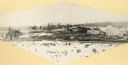
| Date: | 1900 |
|---|---|
| Description: | The town buildings in Irma. Many stumps and milled logs are in the foreground. |
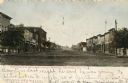
| Date: | 1905 |
|---|---|
| Description: | View down center of Wisconsin Avenue, with commercial buildings and storefronts on both sides. Caption reads: "Wisconsin Ave. on a Quiet Sunday Morning, To... |
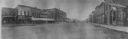
| Date: | 1900 |
|---|---|
| Description: | Panoramic view from right side of street of downtown area. In the right foreground is a man walking near the curb near a sign for a bakery. Further down th... |

| Date: | 1905 |
|---|---|
| Description: | Exterior view of a church, parsonage, and hospital. Caption reads: "Catholic Church, Parsonage and Hospital, Tomahawk, Wis." |

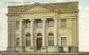
| Date: | 1905 |
|---|---|
| Description: | Elevated view of the hotel on a corner. Horse-drawn vehicles are in the street. Caption reads: "Hotel Badger, Merrill, Wis." |
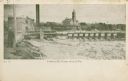
| Date: | 1909 |
|---|---|
| Description: | The Lindaur Mill Flume. A man is standing in the left foreground. In the distance is the Court House with clocktower. Caption reads: "Lindaur Mill Flume, M... |
| Date: | 1908 |
|---|---|
| Description: | Exterior view of the front of the National Bank of Merrill. Two men are standing against the building on the right. There are signs on the second-story win... |
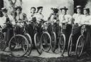
| Date: | 1900 |
|---|---|
| Description: | Studio portrait in front of a painted backdrop of eight young women, each standing and holding a bicycle. Three of the women also hold brownie cameras. |
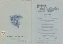
| Date: | 10 29 1908 |
|---|---|
| Description: | Front cover and menu listing from the Hotel Badger, with an etching of a fox sitting on the ground looking up at a bunch of grapes hanging on a vine over a... |

| Date: | 1900 |
|---|---|
| Description: | Photographic postcard view up the Wisconsin River near the foot of Grandfather Falls, which falls 90 feet in 1 1/2 miles. Caption reads: "Near the foot of ... |
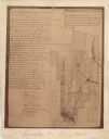
| Date: | 1900 |
|---|---|
| Description: | This map shows areas of Merrill, Corning, Scott, Rock Falls, Russel, Pelisan, Pine River, Ackley, and the Wisconsin River. The left margin of the map inclu... |

| Date: | 1902 |
|---|---|
| Description: | A plat map of Lincoln County showing Township 34 North, Range 8 East. |

| Date: | 1906 |
|---|---|
| Description: | A photocopy of the T.35N, R-8E portion of a map of Lincoln County. |
| Date: | 1907 |
|---|---|
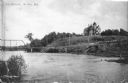
| Description: | View across water towards a large Queen Anne style house sitting on a hill above the Wisconsin River. There is a bridge on the left and a road, now South C... |

| Date: | 1901 |
|---|---|
| Description: | A Sanborn map of Tomahawk featuring the Bay Mill Company's lumber yard. |

| Date: | 1907 |
|---|---|
| Description: | Text on front reads: "Train of House Boats, at Tomahawk, Wis." A train of four houseboats in the water with another boat to pull them. Five rowboats are in... |

| Date: | 1904 |
|---|---|
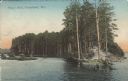
| Description: | Text on front reads: "The Hogs Back, Tomahawk, Wis." The Hogs Back is a tree covered peninsula on Lake Mohawksin, also the former name of Bradley Park. A r... |
| Date: | 1907 |
|---|---|
| Description: | Text on front reads: "Hog's Back, Tomahawk, Wis." The Hog's Back is a tree covered peninsula on Lake Mohawksin, also the former name of Bradley Park. A man... |
If you didn't find the material you searched for, our Library Reference Staff can help.
Call our reference desk at 608-264-6535 or email us at: