Filter: Categories of Wisconsin Historical Images
Filter: County of Lincoln
Filter: Year of 1900-1999
Filter: Categories of Wisconsin Historical Images
Filter: County of Lincoln
Filter: Year of 1900-1999

| Date: | 04 1970 |
|---|---|
| Description: | Wisconsin Congressman David R. Obey speaking at a testimonial dinner marking the first anniversary of his election to Congress. To his right is Mayor Ralph... |

| Date: | 1900 |
|---|---|
| Description: | Studio portrait in front of a painted backdrop of eight young women, each standing and holding a bicycle. Three of the women also hold brownie cameras. |
| Date: | 10 29 1908 |
|---|---|
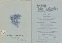
| Description: | Front cover and menu listing from the Hotel Badger, with an etching of a fox sitting on the ground looking up at a bunch of grapes hanging on a vine over a... |
| Date: | 1930 |
|---|---|
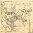
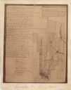
| Description: | This map of Tomahawk shows landownership, an original plat of the city, various plat additions, roads, and railroads. The map includes annotations of road ... |
| Date: | 1943 |
|---|---|
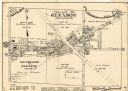
| Description: | This map of the Village of Gleason shows land ownership by name, local streets, railroads, churches, schools, and part of Prairie River. The bottom left of... |

| Date: | 05 1959 |
|---|---|
| Description: | Albert Roszek, wearing overalls, posing with farm machinery. There is a barn in the background. |

| Date: | 1934 |
|---|---|
| Description: | Interior view towards the front of the Lincoln County Court. |

| Date: | 1912 |
|---|---|
| Description: | Group portrait of twelve men posing on the steps and porch of a building, probably forest rangers. The men are wearing a variety of clothing, including a b... |

| Date: | 06 19 1955 |
|---|---|
| Description: | C.L. (Neal) Harrington is second from left at a retirement dinner for Henry Freund. |

| Date: | 1900 |
|---|---|
| Description: | Photographic postcard view up the Wisconsin River near the foot of Grandfather Falls, which falls 90 feet in 1 1/2 miles. Caption reads: "Near the foot of ... |
| Date: | 1940 |
|---|---|
| Description: | This quadrangle collection of maps, meaning geological surveys, shows sections of central and northern Wisconsin. The maps include a quadrangle index map. ... |
| Date: | 1900 |
|---|---|
| Description: | This map shows areas of Merrill, Corning, Scott, Rock Falls, Russel, Pelisan, Pine River, Ackley, and the Wisconsin River. The left margin of the map inclu... |

| Date: | 1923 |
|---|---|
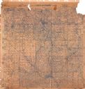
| Description: | This blue line print map shows townships, landownership, roads, residences, churches, schools, town halls, saw mills, and cheese factories. Includes red ma... |

| Date: | 1930 |
|---|---|
| Description: | Exterior view of the Lake Tomahawk Post Office, with a woman and two young girls posed in front. A sign painted on the side of the building advertises "Sod... |

| Date: | 1982 |
|---|---|
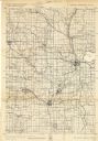
| Description: | This standard U.S.G.S. topographic map was annotated by civil engineer and railroad historian James P. Kaysen to show the location of existing and defunct ... |
| Date: | 11 22 1977 |
|---|---|
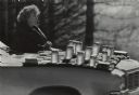
| Description: | Mrs. Gilbert Ward waiting for honey customers along Highway 501. Jars of honey are displayed on a blanket on the hood of her car. |

| Date: | 1902 |
|---|---|
| Description: | A plat map of Lincoln County showing Township 34 North, Range 8 East. |

| Date: | 1906 |
|---|---|
| Description: | A photocopy of the T.35N, R-8E portion of a map of Lincoln County. |
| Date: | 1907 |
|---|---|
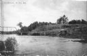
| Description: | View across water towards a large Queen Anne style house sitting on a hill above the Wisconsin River. There is a bridge on the left and a road, now South C... |
If you didn't find the material you searched for, our Library Reference Staff can help.
Call our reference desk at 608-264-6535 or email us at: