Filter: Categories of Wisconsin Historical Images
Filter: County of Lincoln
Filter: Subject of transportation
Filter: Categories of Wisconsin Historical Images
Filter: County of Lincoln
Filter: Subject of transportation

| Date: | 1921 |
|---|---|
| Description: | Warmly-dressed school children riding on the running boards of Theta Mead's car. There is a large building and probably a flag pole in the background. |

| Date: | 1920 |
|---|---|
| Description: | Winter scene with Theta Mead shoveling her car out of a snow drift. |

| Date: | 1918 |
|---|---|
| Description: | Theta Mead standing next to her car on a rural dirt road holding a book under her arm. |

| Date: | 2008 |
|---|---|
| Description: | When Phil Kilinski built this unique Dutch Mill gas station six miles north of Tomahawk in the mid 1940s, he created a whimsical attraction that successful... |

| Date: | 2008 |
|---|---|
| Description: | The windmill structure continues to attract travelers, but not for gasoline or bait, but for ice cream. |
| Date: | |
|---|---|
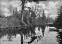
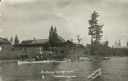
| Description: | View from lake of the buildings of the Sunflower Cottage Resort. People are canoeing and boating in the lake in front of the resort, and a few people are s... |
| Date: | |
|---|---|
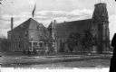
| Description: | Exterior of Saint Mary's Church and Parsonage. The view from across the street shows a United States Flag in front of the parsonage. Caption reads: "St. Ma... |
| Date: | |
|---|---|
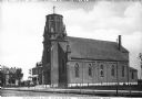
| Description: | Exterior of the Saint Mary's Catholic Church. The view from across the street features the church building's stained glass windows and belfry. Caption read... |
| Date: | |
|---|---|
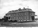
| Description: | Exterior of Sacred Heart Hospital. The brick hospital building features a porch, balcony, and a covered entrance. Caption reads: "Sacred Heart Hospital, To... |
| Date: | |
|---|---|
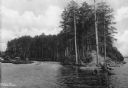
| Description: | Elevated ciew of Bradley Park, named in 1910 after the consolidation of 105 acres previously referred to as Prospect Point and Hog's Back. A man observes m... |
| Date: | |
|---|---|
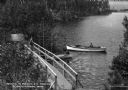
| Description: | A man boats near the shoreline at Prospect Point. Prospect Point consolidated with Hog's Back in 1910 to form 105 acres of land and was renamed Bradley Pa... |

| Date: | 1943 |
|---|---|
| Description: | A map that shows the lands for sale by the Tomahawk Land Company of Tomahawk, Wisconsin, in the counties of Langlade, Lincoln, Oneida, and Price. The map s... |
| Date: | 09 05 1895 |
|---|---|
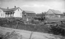
| Description: | View across road of the log buildings and farm home of August Krueger. Two women and three men stand near the fence along the road. One of the men holds a ... |

| Date: | 1915 |
|---|---|
| Description: | This 1915 map of Lincoln County, Wisconsin, shows the township and range grid, towns, cities and villages, lakes and streams, residences, churches, school ... |

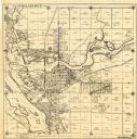
| Date: | 1926 |
|---|---|
| Description: | A map of Lincoln County, Wisconsin that shows the township and range grid, towns, cities and villages, lakes and streams, residences, churches, school hous... |

| Date: | 1900 |
|---|---|
| Description: | Studio portrait in front of a painted backdrop of eight young women, each standing and holding a bicycle. Three of the women also hold brownie cameras. |

| Date: | 1887 |
|---|---|
| Description: | This map of Tomahawk shows the Wisconsin River, numbered lots, and labeled streets. The back of the map reads: "Henry C. Payne, 424 Broadway, - - Milwaukee... |
| Date: | 1930 |
|---|---|
| Description: | This map of Tomahawk shows landownership, an original plat of the city, various plat additions, roads, and railroads. The map includes annotations of road ... |
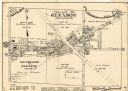
| Date: | 1943 |
|---|---|
| Description: | This map of the Village of Gleason shows land ownership by name, local streets, railroads, churches, schools, and part of Prairie River. The bottom left of... |
If you didn't find the material you searched for, our Library Reference Staff can help.
Call our reference desk at 608-264-6535 or email us at: