 Filter: Categories of Wisconsin Historical Images
Filter: County of Lincoln
Filter: Subject of cities and towns
Filter: Subject of architecture
Filter: Subject of transportation
Filter: Categories of Wisconsin Historical Images
Filter: County of Lincoln
Filter: Subject of cities and towns
Filter: Subject of architecture
Filter: Subject of transportation
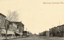
| Date: | 1910 |
|---|---|
| Description: | View down center of unpaved street with storefronts on both sides. Caption reads: "Main Street, Tomahawk, Wis." |
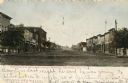
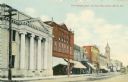
| Date: | 1905 |
|---|---|
| Description: | View down center of Wisconsin Avenue, with commercial buildings and storefronts on both sides. Caption reads: "Wisconsin Ave. on a Quiet Sunday Morning, To... |
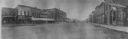
| Date: | 1900 |
|---|---|
| Description: | Panoramic view from right side of street of downtown area. In the right foreground is a man walking near the curb near a sign for a bakery. Further down th... |
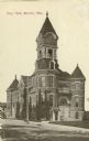
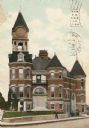
| Date: | 1910 |
|---|---|
| Description: | View across street toward City Hall. Caption reads: "City Hall, Merrill, Wis." |
| Date: | 1910 |
|---|---|
| Description: | Merrill's City Hall and Library. Men are posing in front. |
| Date: | 1910 |
|---|---|
| Description: | The First National Bank on East Main Street. In the distance is the Court House. Caption reads: "First National Bank and East Main Street, Merrill, Wis." |

| Date: | 2008 |
|---|---|
| Description: | When Phil Kilinski built this unique Dutch Mill gas station six miles north of Tomahawk in the mid 1940s, he created a whimsical attraction that successful... |
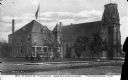
| Date: | |
|---|---|
| Description: | Exterior of Saint Mary's Church and Parsonage. The view from across the street shows a United States Flag in front of the parsonage. Caption reads: "St. Ma... |
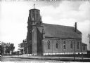
| Date: | |
|---|---|
| Description: | Exterior of the Saint Mary's Catholic Church. The view from across the street features the church building's stained glass windows and belfry. Caption read... |

| Date: | 1915 |
|---|---|
| Description: | This 1915 map of Lincoln County, Wisconsin, shows the township and range grid, towns, cities and villages, lakes and streams, residences, churches, school ... |

| Date: | 1926 |
|---|---|
| Description: | A map of Lincoln County, Wisconsin that shows the township and range grid, towns, cities and villages, lakes and streams, residences, churches, school hous... |

| Date: | 1923 |
|---|---|
| Description: | This blue line print map shows townships, landownership, roads, residences, churches, schools, town halls, saw mills, and cheese factories. Includes red ma... |

| Date: | |
|---|---|
| Description: | Colorized postcard view along Main Street, with several storefronts. Cars are parked along both sides of the street, and streetcar tracks are running down ... |

| Date: | |
|---|---|
| Description: | Slightly elevated view of businesses along Main Street, including a photographer and a barber. A horse-drawn wagon is in the street near the barbershop, an... |

| Date: | |
|---|---|
| Description: | View along shoreline towards the stone bridge with three arches over the Prairie River. There is a stone wall along the opposite shoreline near the bridge.... |

| Date: | 1955 |
|---|---|
| Description: | Text on front reads: "Greetings from Tomahawk, Wisconsin." A aerial view showing the city and Lake Mohawksin on the Wisconsin River. |
If you didn't find the material you searched for, our Library Reference Staff can help.
Call our reference desk at 608-264-6535 or email us at: