 Filter: Categories of Wisconsin Historical Images
Filter: County of Lafayette
Filter: Categories of Wisconsin Historical Images
Filter: County of Lafayette

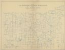
| Date: | 1990 |
|---|---|
| Description: | A tourist map of Lafayette County, Wisconsin, that shows the locations of motels, camping, municipal parks, cheese factory tours, waysides, and golf course... |

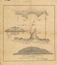
| Date: | 1858 |
|---|---|
| Description: | This 1858 map shows mine shafts, lead veins, and topography on the property of the New Diggings and Shullsburg Mining Company in Section 5 of Township 1 N.... |
| Date: | |
|---|---|
| Description: | This map, based on an 1858 survey, shows the lead vein and the Western Wisconsin Mining Company's mine shafts in a section in the Town of New Diggings, Laf... |

| Date: | 1850 |
|---|---|
| Description: | Ink on paper. Shows local streets and Pekatonika River. "John M. Keep, proprietor. "Original plat of Darlington as surveyed by Richardson on June 14, 1850.... |
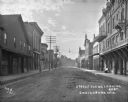
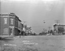
| Date: | 1911 |
|---|---|
| Description: | View down middle of street in a commercial business district. A bakery, a doctor's office and a grocery are on the left. The Opera House, another doctor's ... |
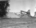
| Date: | |
|---|---|
| Description: | Exterior view of James Mine with a field and fence in the foreground. Tram tracks lead from the tall building to large piles of rocks. There are steep stai... |
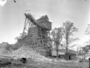
| Date: | 1925 |
|---|---|
| Description: | Exterior view of the Copeland Mine. Entry building, with tram tracks suspended high on scaffolding and piles of rocks below. |

| Date: | 1925 |
|---|---|
| Description: | Ruins of the Old Mill, a stone building which has no roof and is missing window glass. Behind on the left is an abandoned shed. |

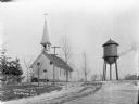
| Date: | 1925 |
|---|---|
| Description: | Exterior view of the Methodist Episcopal Church, a stone building with stained glass windows, a belfry, and a steeple. There is a house next door in the ba... |

| Date: | 1925 |
|---|---|
| Description: | View across lawn of exterior of the Catholic Church, a stone and brick building with stained glass windows. A man is walking down the tree-lined sidewalk o... |
| Date: | |
|---|---|
| Description: | View down unpaved street in a central business district. A Rexall Drug Store is on the corner on the right. A large stone building, which has a sign for "H... |
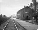
| Date: | 1911 |
|---|---|
| Description: | View down railroad tracks towards the South Wayne depot, with an oncoming train in the distance. Railroad cars are parked on tracks behind the depot. On th... |
| Date: | |
|---|---|
| Description: | View up a road towards the front of the catholic church, which has a steeple and belfry. The double door entrance has an arched stained glass window, and a... |
| Date: | |
|---|---|
| Description: | View down Main Street. On the left a bank is on the corner with a Masonic symbol in the upstairs window. A general store is down the block on the left. Hor... |

| Date: | 02 28 1948 |
|---|---|
| Description: | View up hill of cars driving in the flooded street of the downtown area. The downtown had also flooded in 1923 and 1937. The Pecatonica River rose rapidly ... |

| Date: | 1904 |
|---|---|
| Description: | Map shows townships and sections, landownership and acreages, roads, railroads, post offices, and farms. On the top, bottom, and sides of map are advertise... |
| Date: | 1911 |
|---|---|
| Description: | Map shows routes, post offices, houses, churches, schools, and roads of La Fayette County rural delivery service. The map margins read: "G. January 11, 191... |
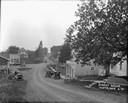
| Date: | 1925 |
|---|---|
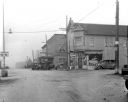
| Description: | View downhill towards a central business district. A restaurant and ice cream parlor are on the right side of the road, and a general store and gas pump ar... |
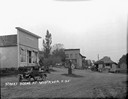
| Date: | 1925 |
|---|---|
| Description: | View of an intersection in the central business district. On the left is the Thomas Knewstubb general store, with a gas pump for Red Crown Gasline out in ... |
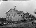
| Date: | 1925 |
|---|---|
| Description: | Three-quarter view of left side and front of the the Wiota Butter and Cheese Company. A wooden flight of stairs leads up to the second floor entrance. Ther... |
If you didn't find the material you searched for, our Library Reference Staff can help.
Call our reference desk at 608-264-6535 or email us at: