Filter: Categories of Wisconsin Historical Images
Filter: County of Lafayette
Filter: Subject of water
Filter: Categories of Wisconsin Historical Images
Filter: County of Lafayette
Filter: Subject of water

| Date: | 1834 |
|---|---|
| Description: | Peck-a-ton-oka (Pecatonica River) with Rodolf farm in the background. |
| Date: | 1871 |
|---|---|
| Description: | Darlington, county seat of Lafayette County, was established in the late 1840s, but didn't thrive until the arrival of the railroad in 1856. This view show... |

| Date: | 1881 |
|---|---|
| Description: | Darlington's first settlers arrived by 1826, attracted by the lead mines of the area. Arrival of the railroad in 1856 stimulated growth, and in 1857 the co... |

| Date: | 1896 |
|---|---|
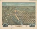
| Description: | Bird's-eye map of Darlington. Area bordered by Washington and North Streets, upper left hand corner, the fairgrounds, upper right corner, River Street, bot... |
| Date: | 1876 |
|---|---|
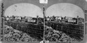
| Description: | Probably one of the "Three different views of the village of Argyle, Wis." mentioned in Dahl's 1877 "Catalogue of Stereoscopic Views." A view of the town a... |

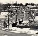
| Date: | 1950 |
|---|---|
| Description: | Aerial view of main street. There is a bridge with a stream flowing under it in the foreground. |
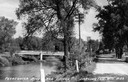
| Date: | 1900 |
|---|---|
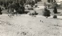
| Description: | Elevated view of wagon bridge in Darlington, with a river on the right, a cow in a field, and a building on the left. |
| Date: | 1959 |
|---|---|
| Description: | Elevated view of street with bridge in Darlington. Cars are parked in the center of the street at an angle. |
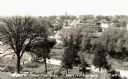
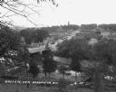
| Date: | 1935 |
|---|---|
| Description: | Elevated view of Darlington, with the bridge over the river in the foreground, and the town beyond. Caption reads: "View from the Hill, Darlington, Wis." |
| Date: | 1935 |
|---|---|
| Description: | View down road, with the Pecatonica River and a bridge on the left. Caption reads: "Pecatonica River and Bridge, Darlington, Wis." |

| Date: | 1910 |
|---|---|
| Description: | Elevated view of the Pecatonica River, which is curving from left to right, making two hairpin turns among fields and trees. Hills are in the distance. |

| Date: | 1957 |
|---|---|
| Description: | Aerial view of Yellowstone Lake and surrounding countryside. |
| Date: | 1898 |
|---|---|
| Description: | Elevated view of a mill pond, with a group of three women and a man standing near the shoreline on the right. |
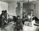
| Date: | 10 12 1938 |
|---|---|
| Description: | International P-30 power unit owned by the Darlington water works. The unit pumped 500 gallons per minute. |
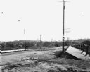
| Date: | |
|---|---|
| Description: | View of Lovers Lane, which a dirt road with a sidewalk and bridge on the right. There are power lines in the foreground, and a town in the background. Ther... |

| Date: | 1925 |
|---|---|
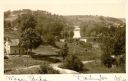
| Description: | View from hill of a landscape with a winding river in a valley. |
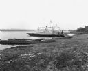
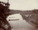
| Date: | 1921 |
|---|---|
| Description: | A man and a child pose on the dock of a paddle ferry boat named "Dewey." An American flag is affixed to the boat, there is a bell attached on a platform ne... |
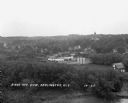
| Date: | 1929 |
|---|---|
| Description: | Elevated view of town looking down a hill. In the foreground is a river with trees along the bank. On the other side of the river is a factory with industr... |
| Date: | 1929 |
|---|---|
| Description: | View down tree-lined hill over the Pecatonica River. The bridge connects River Street to Main Street. Storefronts line the street, and the Lafayette County... |
If you didn't find the material you searched for, our Library Reference Staff can help.
Call our reference desk at 608-264-6535 or email us at: