Filter: Categories of Wisconsin Historical Images
Filter: County of Lafayette
Filter: Subject of roads
Filter: Categories of Wisconsin Historical Images
Filter: County of Lafayette
Filter: Subject of roads

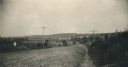
| Date: | 1896 |
|---|---|
| Description: | Bird's-eye map of Darlington. Area bordered by Washington and North Streets, upper left hand corner, the fairgrounds, upper right corner, River Street, bot... |

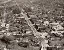
| Date: | 1950 |
|---|---|
| Description: | Aerial view of main street. There is a bridge with a stream flowing under it in the foreground. |
| Date: | 1950 |
|---|---|
| Description: | Aerial view of the main street of town. |
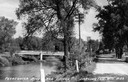
| Date: | 1935 |
|---|---|
| Description: | View toward bridge and hill. The bridge has lampposts. Buildings are on a hill in the background. Caption reads: "Bridge and Hill, Darlington, Wis." |
| Date: | 1935 |
|---|---|
| Description: | View down road, with the Pecatonica River and a bridge on the left. Caption reads: "Pecatonica River and Bridge, Darlington, Wis." |
| Date: | 1930 |
|---|---|
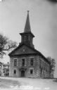
| Description: | Exterior view of the church. Caption reads: "M.E. Church, Shullsburg, Wis." |
| Date: | 1920 |
|---|---|
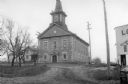
| Description: | Exterior view from road towards a Methodist Episcopal church. The corner of a commercial building is on the right. |
| Date: | 1910 |
|---|---|
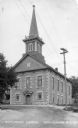
| Description: | Exterior view of the Centenary Methodist Episcopal Church, built in 1867. Caption reads: "Methodist Church, Shullsburg, Wis." |
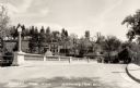
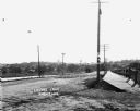
| Date: | 1915 |
|---|---|
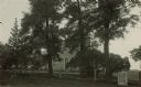
| Description: | View of the Chicago Stageroad marker erected by the local Daughters of the American Revolution. |

| Date: | 1925 |
|---|---|
| Description: | View down middle of street, with pedestrians and storefronts lining both sides. There is a meat market on the left. Automobiles are parked along the curb. |

| Date: | 04 30 1949 |
|---|---|
| Description: | Aerial photograph of Blanchardville. |

| Date: | 11 1980 |
|---|---|
| Description: | View down road of intersection along State Hwy 81. The Frudden Lumber Company Paint Supply Store is on the left. |
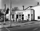
| Date: | |
|---|---|
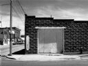
| Description: | View from street of an old brick Ioco gas station with a few cars parked on the left. |
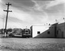
| Date: | |
|---|---|
| Description: | View across parking lot of a school bus and a car parked near a building on the right. In the background there is a metal bridge with trees and houses behi... |
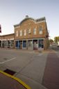
| Date: | 2009 |
|---|---|
| Description: | Exterior view of Copeland Opera House from across street. |
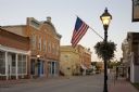
| Date: | 2009 |
|---|---|
| Description: | Exterior view of Copeland Opera House from across the street with flag in foreground. |
| Date: | 05 1981 |
|---|---|
| Description: | Former Firestone Garage, Highland Street at Commercial Avenue. |
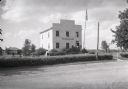
| Date: | 1936 |
|---|---|
| Description: | Exterior view from across road of the first Wisconsin territorial Capitol building, as restored, in Old Belmont (later changed to Leslie). |
| Date: | |
|---|---|
| Description: | View of Lovers Lane, which a dirt road with a sidewalk and bridge on the right. There are power lines in the foreground, and a town in the background. Ther... |
If you didn't find the material you searched for, our Library Reference Staff can help.
Call our reference desk at 608-264-6535 or email us at: