 Filter: Categories of Wisconsin Historical Images
Filter: County of Lafayette
Filter: Subject of rivers
Filter: Subject of streets
Filter: Categories of Wisconsin Historical Images
Filter: County of Lafayette
Filter: Subject of rivers
Filter: Subject of streets
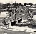
| Date: | 1959 |
|---|---|
| Description: | Elevated view of street with bridge in Darlington. Cars are parked in the center of the street at an angle. |
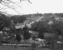
| Date: | 1935 |
|---|---|
| Description: | Elevated view of Darlington, with the bridge over the river in the foreground, and the town beyond. Caption reads: "View from the Hill, Darlington, Wis." |
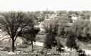
| Date: | 1929 |
|---|---|
| Description: | View down tree-lined hill over the Pecatonica River. The bridge connects River Street to Main Street. Storefronts line the street, and the Lafayette County... |

| Date: | 1850 |
|---|---|
| Description: | Ink on paper. Shows local streets and Pekatonika River. "John M. Keep, proprietor. "Original plat of Darlington as surveyed by Richardson on June 14, 1850.... |

| Date: | 1855 |
|---|---|
| Description: | This map is ink, pen, and watercolor on paper and shows plat of the town, local streets, lots by number, U.S. subdivisions in red lines, Mineral Point Rail... |
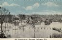
| Date: | 1910 |
|---|---|
| Description: | Elevated view of the Pecatonica River at the bridge. The river is flooding the town. Caption reads: "Pecatonica River on a Rampage, Darlington, , Wis." |

| Date: | 1836 |
|---|---|
| Description: | This map is ink and watercolor on paper and shows a plat of a paper city (a city planned but never built). Some streets and the Pekatolica River are labele... |
If you didn't find the material you searched for, our Library Reference Staff can help.
Call our reference desk at 608-264-6535 or email us at: