 Filter: Categories of Wisconsin Historical Images
Filter: County of Lafayette
Filter: Subject of rivers
Filter: Subject of roads
Filter: Categories of Wisconsin Historical Images
Filter: County of Lafayette
Filter: Subject of rivers
Filter: Subject of roads

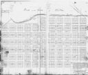
| Date: | 1896 |
|---|---|
| Description: | Bird's-eye map of Darlington. Area bordered by Washington and North Streets, upper left hand corner, the fairgrounds, upper right corner, River Street, bot... |
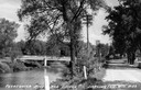
| Date: | 1935 |
|---|---|
| Description: | View down road, with the Pecatonica River and a bridge on the left. Caption reads: "Pecatonica River and Bridge, Darlington, Wis." |
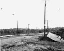
| Date: | |
|---|---|
| Description: | View of Lovers Lane, which a dirt road with a sidewalk and bridge on the right. There are power lines in the foreground, and a town in the background. Ther... |

| Date: | 1830 |
|---|---|
| Description: | An ink on paper, hand-drawn map, showing the wagons roads that travel through Lafayette County, traveling between Galena, Illinois, and Mineral Point, Wisc... |
| Date: | |
|---|---|
| Description: | This photocopy of a map shows the paper city of Wiota on the East Pecatonica River in Lafayette County. After this village failed to prosper, some of its ... |
If you didn't find the material you searched for, our Library Reference Staff can help.
Call our reference desk at 608-264-6535 or email us at: