 Filter: Categories of Wisconsin Historical Images
Filter: County of Lafayette
Filter: Subject of railroads
Filter: Categories of Wisconsin Historical Images
Filter: County of Lafayette
Filter: Subject of railroads

| Date: | 1881 |
|---|---|
| Description: | Darlington's first settlers arrived by 1826, attracted by the lead mines of the area. Arrival of the railroad in 1856 stimulated growth, and in 1857 the co... |

| Date: | 1896 |
|---|---|
| Description: | Bird's-eye map of Darlington. Area bordered by Washington and North Streets, upper left hand corner, the fairgrounds, upper right corner, River Street, bot... |
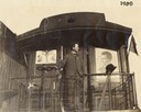
| Date: | 1900 |
|---|---|
| Description: | Robert M. La Follette, Sr., on the back of his campaign train which is decorated with a poster for William McKinley and Theodore Roosevelt national ticket,... |
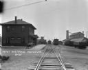
| Date: | 1925 |
|---|---|
| Description: | View down railroad tracks of a locomotive pulling into a railroad depot and yards. The depot is a two-story building. Two wagons are parked near the depot ... |
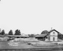
| Date: | |
|---|---|
| Description: | Elevated view across railroad tracks of a lumber yard. A two-story building on the right has a sign that says: "Lovejoy & Ringham". There are fences, a sto... |

| Date: | 1925 |
|---|---|
| Description: | Railroad tank cars on railroad tracks outside the plant. There are two large round storage tanks behind the tank cars. |

| Date: | 1866 |
|---|---|
| Description: | A map of Lafayette County, Wisconsin, showing the townships and ranges, sections, towns, villages, stream and rivers, mounds, mineral deposits and the Mine... |

| Date: | 1904 |
|---|---|
| Description: | Map shows townships and sections, landownership and acreages, roads, railroads, post offices, and farms. On the top, bottom, and sides of map are advertise... |

| Date: | 1882 |
|---|---|
| Description: | Plat map of the village of Dunbarton, received by the Lafayette County Register's Office on September 22, 1892. Certification by the surveyor, Albert Pool,... |

| Date: | 1855 |
|---|---|
| Description: | This map is ink, pen, and watercolor on paper and shows plat of the town, local streets, lots by number, U.S. subdivisions in red lines, Mineral Point Rail... |
If you didn't find the material you searched for, our Library Reference Staff can help.
Call our reference desk at 608-264-6535 or email us at:
