 Filter: Categories of Wisconsin Historical Images
Filter: County of Lafayette
Filter: Subject of landscape
Filter: Categories of Wisconsin Historical Images
Filter: County of Lafayette
Filter: Subject of landscape

| Date: | 1834 |
|---|---|
| Description: | Peck-a-ton-oka (Pecatonica River) with Rodolf farm in the background. |

| Date: | 1910 |
|---|---|
| Description: | Elevated view of the Pecatonica River, which is curving from left to right, making two hairpin turns among fields and trees. Hills are in the distance. |

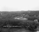
| Date: | 1957 |
|---|---|
| Description: | Aerial view of Yellowstone Lake and surrounding countryside. |

| Date: | 04 30 1949 |
|---|---|
| Description: | Aerial photograph of Blanchardville. |

| Date: | |
|---|---|
| Description: | View from a hilltop looking down at the village. On the hilltop, there is a small tree. In the village are homes, a church, shops, and in the far distance,... |

| Date: | 1913 |
|---|---|
| Description: | View of the village during the winter. There are many homes, shops, several churches and open land. Many of the buildings are two stories high. |

| Date: | 1925 |
|---|---|
| Description: | View down steep road with guard rail. A car is parked on the side of the road on the right. Over the railing, there is a river and a town with a church bui... |

| Date: | 1925 |
|---|---|
| Description: | View from hill of a landscape with a winding river in a valley. |
| Date: | 1925 |
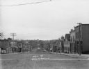
|---|---|
| Description: | View down Main Street looking south. At the bottom of the street is a bridge, and beyond is a hill with houses and trees. There are pedestrians along the s... |
| Date: | 1929 |
|---|---|
| Description: | Elevated view of town looking down a hill. In the foreground is a river with trees along the bank. On the other side of the river is a factory with industr... |
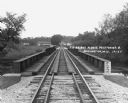
| Date: | 1929 |
|---|---|
| Description: | View down the railroad tracks across the bridge. On the far side are barns and industrial buildings among trees. |

| Date: | 1932 |
|---|---|
| Description: | Several old timbers are exposed on Mud Branch Road. A one-mile stretch of the road was originally constructed as a corduroy road because of "quick sand" in... |

| Date: | |
|---|---|
| Description: | Colorized, elevated view of the Pecatonica River with several of its many curves. Cows are grazing in the pasture in the foreground. The landscape is dotte... |

| Date: | |
|---|---|
| Description: | A vintage view and a modern view of Darlington Road at County Trunk F, presented as a pair. |
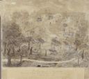
| Date: | 1845 |
|---|---|
| Description: | Drawing of Shullsburg. Text at bottom reads: "Smelting lead ore in log furnaces. Scene in Gratiots Grove at Shullsburg, Wis. in 1845-6. Drawn from life. By... |
If you didn't find the material you searched for, our Library Reference Staff can help.
Call our reference desk at 608-264-6535 or email us at: