Filter: Categories of Wisconsin Historical Images
Filter: County of Lafayette
Filter: Subject of industries
Filter: Categories of Wisconsin Historical Images
Filter: County of Lafayette
Filter: Subject of industries
| Date: | 1900 |
|---|---|
| Description: | View of the Gratiot homestead at Gratiot's Grove Site. |
| Date: | 1900 |
|---|---|
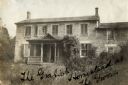
| Description: | Exterior view of the Gratiot homestead at Gratiot's Grove Site. Handwriting on front reads: "The Gratiot Homestead at the (?)on." |

| Date: | 2008 |
|---|---|
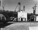
| Description: | Built in 1931 by the Iowa Oil Company, Darlington's Service Station at 404 Main Street was said to give the "impression of a temple or a college chapel, an... |

| Date: | 11 1980 |
|---|---|
| Description: | View down road of intersection along State Hwy 81. The Frudden Lumber Company Paint Supply Store is on the left. |
| Date: | |
|---|---|
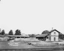
| Description: | View of large building which is depositing feed into a truck docked on its left. On the left there is a Quonset hut-style corrugated metal warehouse, and o... |

| Date: | 1936 |
|---|---|
| Description: | View from road of lead and zinc mines and surrounding buildings. |
| Date: | |
|---|---|
| Description: | View of Marty's Warehouse from across railroad tracks. The warehouse building has large signs of painted lettering advertising the storage facilities. Rail... |
| Date: | 1925 |
|---|---|
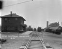
| Description: | View down railroad tracks of a locomotive pulling into a railroad depot and yards. The depot is a two-story building. Two wagons are parked near the depot ... |
| Date: | |
|---|---|
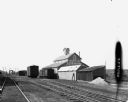
| Description: | Elevated view across railroad tracks of a lumber yard. A two-story building on the right has a sign that says: "Lovejoy & Ringham". There are fences, a sto... |

| Date: | 1925 |
|---|---|
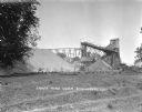
| Description: | Railroad tank cars on railroad tracks outside the plant. There are two large round storage tanks behind the tank cars. |
| Date: | 1929 |
|---|---|
| Description: | Elevated view of town looking down a hill. In the foreground is a river with trees along the bank. On the other side of the river is a factory with industr... |

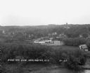
| Date: | 1924 |
|---|---|
| Description: | The Blackstone Mine property and mining equipment. |

| Date: | 1866 |
|---|---|
| Description: | A map of Lafayette County, Wisconsin, showing the townships and ranges, sections, towns, villages, stream and rivers, mounds, mineral deposits and the Mine... |

| Date: | 1858 |
|---|---|
| Description: | This 1858 map shows mine shafts, lead veins, and topography on the property of the New Diggings and Shullsburg Mining Company in Section 5 of Township 1 N.... |
| Date: | |
|---|---|
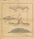
| Description: | This map, based on an 1858 survey, shows the lead vein and the Western Wisconsin Mining Company's mine shafts in a section in the Town of New Diggings, Laf... |
| Date: | |
|---|---|
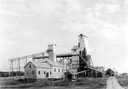
| Description: | Exterior view of James Mine with a field and fence in the foreground. Tram tracks lead from the tall building to large piles of rocks. There are steep stai... |
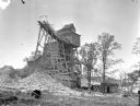
| Date: | 1925 |
|---|---|
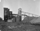
| Description: | Exterior view of the Copeland Mine. Entry building, with tram tracks suspended high on scaffolding and piles of rocks below. |
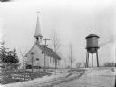
| Date: | |
|---|---|
| Description: | View up a road towards the front of the catholic church, which has a steeple and belfry. The double door entrance has an arched stained glass window, and a... |
If you didn't find the material you searched for, our Library Reference Staff can help.
Call our reference desk at 608-264-6535 or email us at: