Filter: Categories of Wisconsin Historical Images
Filter: County of La Crosse
Filter: Year of 1900-1999
Filter: Year of 1950-1959
Filter: Categories of Wisconsin Historical Images
Filter: County of La Crosse
Filter: Year of 1900-1999
Filter: Year of 1950-1959

| Date: | 1955 |
|---|---|
| Description: | Aerial view of river and town from a military airplane. |

| Date: | 1955 |
|---|---|
| Description: | Aerial view of La Crosse, with Onalaska in the background. The highway is U.S. Highway 53 and the State Highway 35. |

| Date: | 1953 |
|---|---|
| Description: | Aerial view of La Crosse and the Mississippi River. In the foreground is the new bridge as of 1953. |
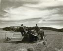
| Date: | 1950 |
|---|---|
| Description: | A farmer and a young boy ride a tractor through a field reaping oats. |

| Date: | 11 1951 |
|---|---|
| Description: | Aerial view of US Highway 14 southeast of La Crosse descending into Mormon Coulee. The original caption of the print, which is undated, describes the road ... |

| Date: | 12 24 1958 |
|---|---|
| Description: | Child sleeping in front of the fireplace, waiting for Santa Claus to arrive. |

| Date: | 1950 |
|---|---|
| Description: | Aerial view of a farm and surrounding fields farmed with the contour method. Shocks of grain dot several of the fields. |

| Date: | 03 13 1956 |
|---|---|
| Description: | Group portrait of the Lacrosse Central Red Raiders basketball team. |

| Date: | 1958 |
|---|---|
| Description: | Head and shoulders portrait of an elderly woman; hanging on the wall behind her is an antique clock. |

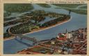
| Date: | 1950 |
|---|---|
| Description: | This map is intended for tourists visiting La Crosse. The front of the map provides extensive text on attractions and activities in La Crosse while the bac... |

| Date: | 1954 |
|---|---|
| Description: | This map of La Crosse shows residential, multiple dwelling, local business, commercial, light industrial, heavy industrial and special multiple dwelling la... |

| Date: | 1956 |
|---|---|
| Description: | This map is intended for tourists of La Crosse. The front of the map is text about attractions, activities, and accommodations in La Crosse. The back is th... |
| Date: | 1951 |
|---|---|
| Description: | Aerial view of a highway bridge crossing the Mississippi River and French Island. Caption reads: "New Bridge over Mississippi River, La Crosse, Wis." |

| Date: | 1950 |
|---|---|
| Description: | View of a driveway and sidewalk along the Mississippi River. An interstate bridge and bluffs are in the distance. Caption reads: "Driveway, Pettibone Park,... |

| Date: | 1955 |
|---|---|
| Description: | A motorboat on Lake Neshonoc is speeding toward the public landing, where there is a car parked and a small group of people has gathered. A man in a swimmi... |
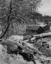
| Date: | 1950 |
|---|---|
| Description: | A boathouse, boat and pier on the frozen shoreline of the Mississippi River. More buildings appear in the background, a snow covered tree on the left and a... |
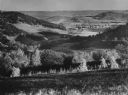
| Date: | 1953 |
|---|---|
| Description: | Elevated view along a hillside into a valley, with forests, buildings, and crop fields. Caption reads: "Barree Coulee from St. Joseph's Ridge, La Crosse Co... |

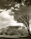
| Date: | 1952 |
|---|---|
| Description: | A Native American man performing a fire dance at Camp Decorah. |
If you didn't find the material you searched for, our Library Reference Staff can help.
Call our reference desk at 608-264-6535 or email us at: