 Filter: Categories of Wisconsin Historical Images
Filter: County of La Crosse
Filter: Year of 1900-1999
Filter: Categories of Wisconsin Historical Images
Filter: County of La Crosse
Filter: Year of 1900-1999
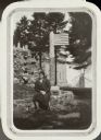
| Date: | 1931 |
|---|---|
| Description: | Miss Barbara Kiechler, identified as a 4-H Club worker in Coon Valley, posing on a low wall surrounding the Grotto of the Holy Family on the grounds of Vil... |

| Date: | 1931 |
|---|---|
| Description: | Mrs. Lou Stark, president of the PTA at Lower Big Creek School, poses in front of her farmhouse. |

| Date: | 1931 |
|---|---|
| Description: | Students at Victory School, La Crosse County, pose at the side of their stone school building. All the boys are wearing neckties. |

| Date: | 1958 |
|---|---|
| Description: | Head and shoulders portrait of an elderly woman; hanging on the wall behind her is an antique clock. |

| Date: | 1900 |
|---|---|
| Description: | This map of Bangor is ink and pencil on cloth. The map shows roads, railroads, residences, mills, the original plat of Bangor, and the Wisconsin and Wheldo... |

| Date: | 1940 |
|---|---|
| Description: | This map of La Crosse shows different types of land zoning: residence, multiple dwelling, local business, commercial, light industrial, heavy industrial, w... |

| Date: | 1950 |
|---|---|
| Description: | This map is intended for tourists visiting La Crosse. The front of the map provides extensive text on attractions and activities in La Crosse while the bac... |

| Date: | 1954 |
|---|---|
| Description: | This map of La Crosse shows residential, multiple dwelling, local business, commercial, light industrial, heavy industrial and special multiple dwelling la... |

| Date: | 1956 |
|---|---|
| Description: | This map is intended for tourists of La Crosse. The front of the map is text about attractions, activities, and accommodations in La Crosse. The back is th... |

| Date: | 1970 |
|---|---|
| Description: | This map is intended for tourists of La Crosse. The cover features images of farms and natural land and reads: "friends are but strangers... we have yet to... |

| Date: | 1972 |
|---|---|
| Description: | This map of La Crosse is a plan for the city parks and recreation areas. The cover features an explanation of the Park and Recreation plan, objectives of t... |

| Date: | 1995 |
|---|---|
| Description: | This map of La Crosse is a bird’s-eye-view map with relief shown pictorially. The cover lists many points of interests and activities in La Crosse. The cov... |

| Date: | 1900 |
|---|---|
| Description: | This map of La Crosse shows twenty wards, some rural lots with acreages, streets, railroads, depots, bridges, cemeteries, parks, schools, islands, and the ... |
| Date: | 1900 |
|---|---|
| Description: | This map of the south side addition to La Crosse shows lot and block numbers, dimensions, and streets. |

| Date: | 1900 |
|---|---|
| Description: | The map is watercolor, pencil, and ink on tracing cloth and shows plats of both cities, local streets, railroads, mills, township divisions, bridges, and p... |
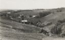
| Date: | 1936 |
|---|---|
| Description: | View down hill towards valley of farming country in the “Coulee Region.” |

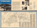
| Date: | 1927 |
|---|---|
| Description: | This map includes an index and highways marked in red. Attractions on the map include: Four Mile House, Cold Springs, Grand Crossing Station, Coleman Sloug... |

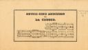
| Date: | 1900 |
|---|---|
| Description: | This map is pencil on tracing paper and shows profiles of local streets. Sheet 6 is hand-colored and some sheets are missing. |
| Date: | 1960 |
|---|---|
| Description: | This map is oriented with north to the right and includes an index of streets. The back of the map features text about La Crosse. |
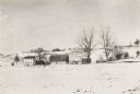
| Date: | 1920 |
|---|---|
| Description: | Winter scene with snow-covered fields at the Thomas Pederson farm, near Holmen. |
If you didn't find the material you searched for, our Library Reference Staff can help.
Call our reference desk at 608-264-6535 or email us at: