 Filter: Categories of Wisconsin Historical Images
Filter: County of La Crosse
Filter: Year of 1900-1999
Filter: Type of Map or Atlas
Filter: Subject of streets
Filter: Categories of Wisconsin Historical Images
Filter: County of La Crosse
Filter: Year of 1900-1999
Filter: Type of Map or Atlas
Filter: Subject of streets

| Date: | 1900 |
|---|---|
| Description: | This map of Bangor is ink and pencil on cloth. The map shows roads, railroads, residences, mills, the original plat of Bangor, and the Wisconsin and Wheldo... |

| Date: | 1940 |
|---|---|
| Description: | This map of La Crosse shows different types of land zoning: residence, multiple dwelling, local business, commercial, light industrial, heavy industrial, w... |

| Date: | 1954 |
|---|---|
| Description: | This map of La Crosse shows residential, multiple dwelling, local business, commercial, light industrial, heavy industrial and special multiple dwelling la... |

| Date: | 1956 |
|---|---|
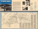
| Description: | This map is intended for tourists of La Crosse. The front of the map is text about attractions, activities, and accommodations in La Crosse. The back is th... |

| Date: | 1970 |
|---|---|
| Description: | This map is intended for tourists of La Crosse. The cover features images of farms and natural land and reads: "friends are but strangers... we have yet to... |

| Date: | 1900 |
|---|---|
| Description: | This map of La Crosse shows twenty wards, some rural lots with acreages, streets, railroads, depots, bridges, cemeteries, parks, schools, islands, and the ... |
| Date: | 1900 |
|---|---|
| Description: | This map of the south side addition to La Crosse shows lot and block numbers, dimensions, and streets. |

| Date: | 1900 |
|---|---|
| Description: | The map is watercolor, pencil, and ink on tracing cloth and shows plats of both cities, local streets, railroads, mills, township divisions, bridges, and p... |

| Date: | 1927 |
|---|---|
| Description: | This map includes an index and highways marked in red. Attractions on the map include: Four Mile House, Cold Springs, Grand Crossing Station, Coleman Sloug... |

| Date: | 1900 |
|---|---|
| Description: | This map is pencil on tracing paper and shows profiles of local streets. Sheet 6 is hand-colored and some sheets are missing. |
| Date: | 1960 |
|---|---|
| Description: | This map is oriented with north to the right and includes an index of streets. The back of the map features text about La Crosse. |
If you didn't find the material you searched for, our Library Reference Staff can help.
Call our reference desk at 608-264-6535 or email us at:
