 Filter: Categories of Wisconsin Historical Images
Filter: County of La Crosse
Filter: Year of 1800-1899
Filter: Year of 1870-1879
Filter: Categories of Wisconsin Historical Images
Filter: County of La Crosse
Filter: Year of 1800-1899
Filter: Year of 1870-1879

| Date: | 1873 |
|---|---|
| Description: | The harbor, showing the sidewheel packet, "Belle of La Crosse," and the sidewheel ferry "Alex McGregor." Other boats are also seen including two barges loa... |

| Date: | 1873 |
|---|---|
| Description: | Bird's-eye map of La Crosse from the Mississippi River. |
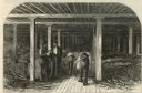
| Date: | 1877 |
|---|---|
| Description: | Etching of interior of bonded warehouse with four men present, two conversing and two rolling barrels. |
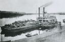
| Date: | 1875 |
|---|---|
| Description: | View down hill towards "Diamond Jo" steamboat docked on the shoreline of the Mississippi River while goods are being loaded onto the steamboat. |

| Date: | 1873 |
|---|---|
| Description: | A map that covers parts of Winona and Houston Counties, Minnesota and La Crosse County, Wisconsin, showing the proposed railroad routes, constructed rail l... |
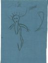
| Date: | 06 1879 |
|---|---|
| Description: | Tracing of a cave petroglyph depicting a human figure wearing headgear. A club is depicted to the right of the figure. |
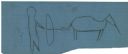
| Date: | 06 1879 |
|---|---|
| Description: | Tracing of a petroglyph depicting an animal figure pursued by a human figure with a bow and arrow followed by a child. |

| Date: | 06 1879 |
|---|---|
| Description: | Tracing of a petroglyph depicting an animal that has been shot with an arrow. |

| Date: | 1874 |
|---|---|
| Description: | Map shows townships and sections, landownership and acreages, railroads, and roads. The map was compiled by the civil engineer and city surveyor agent H.I.... |

| Date: | 1870 |
|---|---|
| Description: | This map of the Village of North La Crosse is partially hand-drawn and includes text about the land in the lower margin. |

| Date: | 1874 |
|---|---|
| Description: | This map of La Crosse is accompanied by other plats of subdivision of the city. The relief is shown by hachures. The additions include: Rudolf Gripps Addit... |

| Date: | 1872 |
|---|---|
| Description: | This map is pencil, ink, and watercolor on paper. Shown on the map is the elevation and profile of La Crescent Bottoms, Mt. Vernon Street line, 13th Street... |

| Date: | 1874 |
|---|---|
| Description: | This map has relief shown by hachures and includes 7 inset maps of additions and subdivisions with varying scales. Also includes index of additions and loc... |

| Date: | 1876 |
|---|---|
| Description: | This map is ink on tracing cloth and shows the Black River, French Slough, Little French Slough, the southern portion of North La Crosse, the Milwaukee & S... |
If you didn't find the material you searched for, our Library Reference Staff can help.
Call our reference desk at 608-264-6535 or email us at:
