Filter: Categories of Wisconsin Historical Images
Filter: County of La Crosse
Filter: Year of 1800-1899
Filter: Subject of human settlements
Filter: Categories of Wisconsin Historical Images
Filter: County of La Crosse
Filter: Year of 1800-1899
Filter: Subject of human settlements

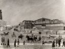
| Date: | 1873 |
|---|---|
| Description: | The harbor, showing the sidewheel packet, "Belle of La Crosse," and the sidewheel ferry "Alex McGregor." Other boats are also seen including two barges loa... |

| Date: | 1867 |
|---|---|
| Description: | Bird's-eye map of La Crosse with nine insets of residences, schools, and the Court House and Jail. |

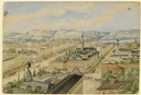
| Date: | 1873 |
|---|---|
| Description: | Bird's-eye map of La Crosse from the Mississippi River. |

| Date: | 1887 |
|---|---|
| Description: | Bird's-eye map of La Crosse, with six insets including residences, a store front, The John Gund Brewing Company, and C. & J. Michel Brewing Company. |
| Date: | 04 1860 |
|---|---|
| Description: | Accompanying this sketch is Hölzlhuber's description of his last foray from Milwaukee before leaving America. "Before my return to Europe, D. Brandis, the ... |
| Date: | 1891 |
|---|---|
| Description: | A painting of the new (as of 1891) bridge over the Mississippi River in La Crosse. The bridge was built by the Clinton Bridge Co. Captions read: "North sid... |
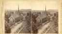
| Date: | 1880 |
|---|---|
| Description: | Stereograph of an elevated view of the Congregational Church. View is from the high school looking down Main Street. |
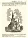
| Date: | 06 26 1869 |
|---|---|
| Description: | An engraving from the Billed-Magazine of the First Congregational Church. |
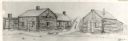
| Date: | 1842 |
|---|---|
| Description: | Drawing of Front and State Streets, showing the first houses in La Crosse. |
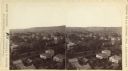
| Date: | 1886 |
|---|---|
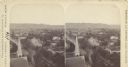
| Description: | Stereograph view, looking northeast from the high school. |
| Date: | 1886 |
|---|---|
| Description: | Stereograph view, looking east from the high school, of La Crosse. |
| Date: | 1877 |
|---|---|
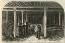
| Description: | Etching of interior of bonded warehouse with four men present, two conversing and two rolling barrels. |

| Date: | 1873 |
|---|---|
| Description: | A map that covers parts of Winona and Houston Counties, Minnesota and La Crosse County, Wisconsin, showing the proposed railroad routes, constructed rail l... |

| Date: | 1890 |
|---|---|
| Description: | This manuscript map of Township 16 North, Range 6 West, 4th Principal Meridian, encompasses the Town of Barre and the southern portion of the Town of Hamil... |

| Date: | 1890 |
|---|---|
| Description: | This late 19th century map shows sections, state lands, Barre Center P.O. (now Barre Mills), railroads, topography, and streams and wetlands in the Town of... |

| Date: | 1857 |
|---|---|
| Description: | Map of La Crosse County, Wisconsin showing village plat, farm houses, schools, roads, railroads, township names (New Amsterdam, Dacota, Minnesota, Driesbac... |

| Date: | 1874 |
|---|---|
| Description: | Map shows townships and sections, landownership and acreages, railroads, and roads. The map was compiled by the civil engineer and city surveyor agent H.I.... |
If you didn't find the material you searched for, our Library Reference Staff can help.
Call our reference desk at 608-264-6535 or email us at: