 Filter: Categories of Wisconsin Historical Images
Filter: County of La Crosse
Filter: Subject of cities and towns
Filter: Categories of Wisconsin Historical Images
Filter: County of La Crosse
Filter: Subject of cities and towns
| Date: | |
|---|---|
| Description: | This 19th century manuscript map shows state lands and acreages along the Mississippi River and the sections in parts of what is currently the Town of Shel... |

| Date: | 1890 |
|---|---|
| Description: | This late 19th century map shows sections, state lands, Barre Center P.O. (now Barre Mills), railroads, topography, and streams and wetlands in the Town of... |
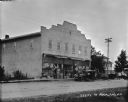
| Date: | 1922 |
|---|---|
| Description: | View across road of the Berg & Jones Department Store, with posters in the front windows announcing an upcoming Ringling Brothers Barnum and Bailey Circus ... |
| Date: | 1924 |
|---|---|
| Description: | View down unpaved street towards a general store on the left. The sign on the awning in front reads: "Homstad Store." A gas pump, parked car and large tree... |
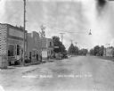
| Date: | 1924 |
|---|---|
| Description: | View down Prospect Avenue, with men sitting on a bench by the "Steponet" gas pumps in front of a storefront. A man stands on the sidewalk in front of the b... |
| Date: | 1924 |
|---|---|
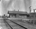
| Description: | View down tracks towards man standing in front of the Union Depot. There is a "Seeds Feed" sign on a building in the background. In the foreground is a lam... |
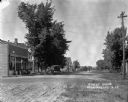
| Date: | 1911 |
|---|---|
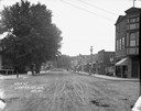
| Description: | View down middle of unpaved Main Street. There are large trees along the sidewalk on the left. Businesses line both sides of the street, and there is a sta... |
| Date: | 1922 |
|---|---|
| Description: | View down center of Main Street with cobblestones. There is a railroad crossing in the foreground. Service garages are on the left and right corners. Parke... |
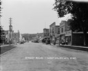
| Date: | 1929 |
|---|---|
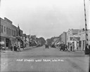
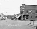
| Description: | View down middle of street towards central business section. On the left is a building with a belfry. Cars and businesses line both sides of the street, pe... |
| Date: | 1922 |
|---|---|
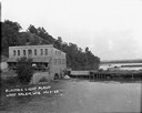
| Description: | Elevated view across water of a stone building next to an earthen dam on the La Crosse River. There is an archway on the side of the building at the river ... |
| Date: | 1911 |
|---|---|
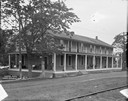
| Description: | View across railroad tracks and road of the front of the Hotel May. The hotel has a wrap-around porch and balcony. Men in suits are relaxing in chairs on t... |
| Date: | |
|---|---|
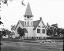
| Description: | Three-quarter view from across a road of the Affiliated Church. An arched stained glass window is in the front on the left. Tall rectangular stained glass ... |
| Date: | 1926 |
|---|---|
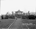
| Description: | View down path of Memorial Park. A pavilion in the center is surrounded by bushes and plants. |
| Date: | 1929 |
|---|---|
| Description: | View down middle of Main Street paved with cobblestones. There is a railroad crossing at the far end, and the ridge of a hill in the far background. A barb... |

| Date: | 1857 |
|---|---|
| Description: | Map of La Crosse County, Wisconsin showing village plat, farm houses, schools, roads, railroads, township names (New Amsterdam, Dacota, Minnesota, Driesbac... |

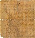
| Date: | 1874 |
|---|---|
| Description: | Map shows townships and sections, landownership and acreages, railroads, and roads. The map was compiled by the civil engineer and city surveyor agent H.I.... |

| Date: | 1931 |
|---|---|
| Description: | Relief shown by contours and spot heights. Maps shows United States, state, county and local highways and roads, schools, North Bend, creeks, lakes, rivers... |

| Date: | |
|---|---|
| Description: | Photographic postcard view down a tree-lined street in a residential neighborhood. Caption reads: "Burns Street, Bangor, Wis." |

| Date: | 1900 |
|---|---|
| Description: | This map of Bangor is ink and pencil on cloth. The map shows roads, railroads, residences, mills, the original plat of Bangor, and the Wisconsin and Wheldo... |

| Date: | 1856 |
|---|---|
| Description: | This map of the City of La Crosse is a plat of Pike & Co's Addition. The map shows street names, block and lot numbers, the South La Crosse River, and the ... |
If you didn't find the material you searched for, our Library Reference Staff can help.
Call our reference desk at 608-264-6535 or email us at: