Filter: Categories of Wisconsin Historical Images
Filter: County of La Crosse
Filter: Subject of botany
Filter: Subject of roads
Filter: Categories of Wisconsin Historical Images
Filter: County of La Crosse
Filter: Subject of botany
Filter: Subject of roads

| Date: | 1867 |
|---|---|
| Description: | Bird's-eye map of La Crosse with nine insets of residences, schools, and the Court House and Jail. |
| Date: | 04 22 1965 |
|---|---|
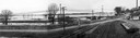
| Description: | A panoramic view of the Mississippi River flooding during the spring, showing the dykes built along the Chicago, Burlington & Quincy Railroad tracks at Sec... |
| Date: | |
|---|---|
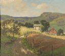
| Description: | View from road towards farm buildings at the base of the bluff. A horse-drawn vehicle is on the rod. Caption reads: "Grand Dad's Bluff, La Crosse, Wis." |
| Date: | 1915 |
|---|---|
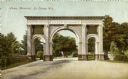
| Description: | The Losey Memorial Arch, built in honor of Joseph W. Losey. Mr. Losey was an early pioneer lawyer of the town, made District Attorney in 1857 and City Atto... |

| Date: | 1909 |
|---|---|
| Description: | View across street toward the hospital. Caption reads: "Lutheran Hospital, La Crosse, Wis." |

| Date: | 1900 |
|---|---|
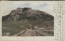
| Description: | Elevated view of La Crosse. Caption reads: "Panorama of La Crosse, Wis. from Grand Dad's Bluff." |

| Date: | 11 1951 |
|---|---|
| Description: | Aerial view of US Highway 14 southeast of La Crosse descending into Mormon Coulee. The original caption of the print, which is undated, describes the road ... |
| Date: | 1909 |
|---|---|
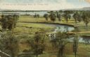
| Description: | Elevated view of winding tributaries leading to Mississippi River. A road passes over a bridge in the foreground. Caption reads: "A View on the Mississippi... |
| Date: | |
|---|---|
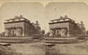
| Description: | Stereograph. The house stands back from a dirt road behind a fence and yard. |

| Date: | |
|---|---|
| Description: | Aerial view of the Villa St. Joseph featuring the main house in the center of the image, surrounded by a road and many smaller dwellings. A road runs in fr... |

| Date: | 1950 |
|---|---|
| Description: | Aerial view of a farm and surrounding fields farmed with the contour method. Shocks of grain dot several of the fields. |

| Date: | |
|---|---|
| Description: | View down Main Street dirt road. A horse and buggy stand near a sidewalk on the left near a group of men. Further down on the right the Bangor State Bank h... |

| Date: | |
|---|---|
| Description: | View down dirt road with destroyed buildings on both sides. There are many piles of rubble, and some buildings are gutted shells. Pedestrians walk along ro... |

| Date: | |
|---|---|
| Description: | Residential scene with a dirt road and homes on both sides. There is a church building in the middle distance, and bluffs in the background. |

| Date: | |
|---|---|
| Description: | View of railroad tracks near a railroad station on the left and a residential road on the right. There is a row of utility lines leading into the far dista... |

| Date: | 1911 |
|---|---|
| Description: | View down dirt road. There is a millinery, dentist's office, drug store, Elsen House ice cream, and meat market. There are horse-drawn carriages on either ... |

| Date: | |
|---|---|
| Description: | Exterior view across road of Lutheran church with stained glass and a steeple with a bell and cross. A horse and carriage are moving down the street on the... |
If you didn't find the material you searched for, our Library Reference Staff can help.
Call our reference desk at 608-264-6535 or email us at: