 Filter: Categories of Wisconsin Historical Images
Filter: County of La Crosse
Filter: Type of Map or Atlas
Filter: Subject of land
Filter: Subject of streets
Filter: Categories of Wisconsin Historical Images
Filter: County of La Crosse
Filter: Type of Map or Atlas
Filter: Subject of land
Filter: Subject of streets

| Date: | 1900 |
|---|---|
| Description: | This map of Bangor is ink and pencil on cloth. The map shows roads, railroads, residences, mills, the original plat of Bangor, and the Wisconsin and Wheldo... |

| Date: | 1856 |
|---|---|
| Description: | This map of the City of La Crosse is a plat of Pike & Co's Addition. The map shows street names, block and lot numbers, the South La Crosse River, and the ... |

| Date: | 1870 |
|---|---|
| Description: | This map of the Village of North La Crosse is partially hand-drawn and includes text about the land in the lower margin. |

| Date: | 1874 |
|---|---|
| Description: | This map of La Crosse is accompanied by other plats of subdivision of the city. The relief is shown by hachures. The additions include: Rudolf Gripps Addit... |

| Date: | 1891 |
|---|---|
| Description: | This map of La Crosse shows eighteen city wards in red, railroads, cemeteries, fair grounds, labeled streets, islands, and the Mississippi River. The left ... |

| Date: | 1893 |
|---|---|
| Description: | This map of La Crosse shows wards 1-20, streets, railroads, the Inter State Fair Grounds, islands, and the Mississippi River. Relief is shown by hachures. ... |

| Date: | 1940 |
|---|---|
| Description: | This map of La Crosse shows different types of land zoning: residence, multiple dwelling, local business, commercial, light industrial, heavy industrial, w... |

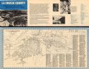
| Date: | 1956 |
|---|---|
| Description: | This map is intended for tourists of La Crosse. The front of the map is text about attractions, activities, and accommodations in La Crosse. The back is th... |

| Date: | 1800 |
|---|---|
| Description: | This map of the Village of North La Crosse was likely published before 1871 and shows street names, additions, section and lot numbers, railroads (specific... |

| Date: | 1800 |
|---|---|
| Description: | This map of North La Crosse is ink and pencil on paper and shows lot ownership and buildings. |

| Date: | 1857 |
|---|---|
| Description: | This map show city plats including the name and number of the plats as well as some land ownership. Some of the plats have manuscript annotations outlined ... |

| Date: | 1859 |
|---|---|
| Description: | This map show plats including plat names, plat numbers, and some lot owner's names. Relief is shown by hachures. The map includes line drawings of Juneau B... |

| Date: | 1874 |
|---|---|
| Description: | This map has relief shown by hachures and includes 7 inset maps of additions and subdivisions with varying scales. Also includes index of additions and loc... |

| Date: | 1900 |
|---|---|
| Description: | The map is watercolor, pencil, and ink on tracing cloth and shows plats of both cities, local streets, railroads, mills, township divisions, bridges, and p... |

| Date: | 1857 |
|---|---|
| Description: | This map shows section corners, quarter section corners, foundry, steam saw mill, steam grist mill, planning mill, court house, baptist church, congregatio... |
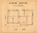
| Date: | 1800 |
|---|---|
| Description: | This map show a plat and covers the area bordered by Main to King streets and from 15th to 17th streets. |
| Date: | 1960 |
|---|---|
| Description: | This map is oriented with north to the right and includes an index of streets. The back of the map features text about La Crosse. |
If you didn't find the material you searched for, our Library Reference Staff can help.
Call our reference desk at 608-264-6535 or email us at:

