Filter: Categories of Wisconsin Historical Images
Filter: County of Kewaunee
Filter: Year of 1900-1999
Filter: Categories of Wisconsin Historical Images
Filter: County of Kewaunee
Filter: Year of 1900-1999
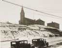
| Date: | 1934 |
|---|---|
| Description: | Terracing on Ellis Street during the winter. Two automobiles are parked alongside the road in the foreground. The terraced hill is snow covered, and a chur... |
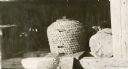
| Date: | 1932 |
|---|---|
| Description: | Bee skep turned over to show bees and combs inside. |

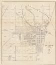
| Date: | 1961 |
|---|---|
| Description: | This map shows streets and some points of interest. Kewaunee River and Lake Michigan are both labeled. |

| Date: | 01 07 1958 |
|---|---|
| Description: | View from the Second Street bridge over the icy Ahnapee River towards Lake Michigan. A lighthouse is at the end of a jetty in the far background. Boats are... |
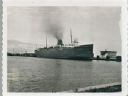
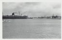
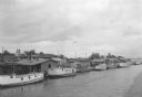
| Date: | 09 15 1960 |
|---|---|
| Description: | View across water towards a carferry named "City of Flint," moored at a dock. There are buildings on the dock on the right. |
| Date: | 01 07 1958 |
|---|---|
| Description: | View across water to ship moored at a dock. Smoke is coming out of the smokestack. Industrial buildings are across the water on the right. |
| Date: | 1930 |
|---|---|
| Description: | This cadastral map shows ownership and acreage of lots. Streets, the Kewaunee River, and Lake Michigan are labeled. |

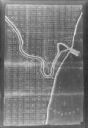
| Date: | 1926 |
|---|---|
| Description: | This blueprint manuscript map shows buildings, railroads, and United States property. Water depths shown by soundings, tints, and isolines. |

| Date: | 1937 |
|---|---|
| Description: | This is map 1 from a set of 4 taken from an atlas. The map shows streets, neighborhoods and proposed subdivision. Lake Michigan, Algoma Outer Harbor, the A... |
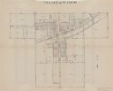
| Date: | 1937 |
|---|---|
| Description: | This is map 2 from a set of 4 taken from an atlas. The map shows streets, railroad tracks, and plots. The back of the map includes an index of residents of... |

| Date: | 1937 |
|---|---|
| Description: | This is map 3 from a set of 4 taken from an atlas. The map shows streets, neighborhoods, lots, and railroad tracks. Lake Michigan, the Kewaunee River, and ... |

| Date: | 1937 |
|---|---|
| Description: | This is map 4 from a set of 4 taken from an atlas. The map includes a legend in the lower left corner of roads, trails, county lines, town lines, section l... |

| Date: | 1955 |
|---|---|
| Description: | This map shows roads, trails, county lines, town borders, section lines, railroads, rivers, lakes, and Lake Michigan on the far right. The bottom margin in... |
| Date: | 1900 |
|---|---|
| Description: | This photocopy map shows land parcels, block numbers, streets, the Kewaunee River, and Lake Michigan on the far right side. The original map was created ar... |
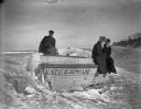
| Date: | 1912 |
|---|---|
| Description: | Hattie Taylor and her neighbors on the icy shoreline of Lake Michigan near the row boat "Kate E. Howard." |
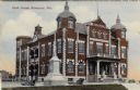
| Date: | 1908 |
|---|---|
| Description: | Colorized postcard view of the Kauwaunee County Courthouse and adjoining veterans' memorial. The monument is flanked by cannons. Caption reads: "Court Hous... |
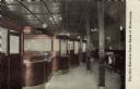
| Date: | 1915 |
|---|---|
| Description: | View of the interior of a bank, with a row of teller cages on the left, and columns on the right. The president's office is on the far left. Caption reads:... |
| Date: | 07 1936 |
|---|---|
| Description: | Elevated view of seagulls flying over fishing tugs moored at the wharf in Algoma. Small warehouse buildings line the wharf. Fish net drying reels are visib... |
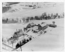
| Date: | 1955 |
|---|---|
| Description: | Aerial view of a farm in winter, with the farmhouse, barn, and outbuildings blanketed in snow. The name Cedar Spring Farm is on the barn. Another farm is i... |
If you didn't find the material you searched for, our Library Reference Staff can help.
Call our reference desk at 608-264-6535 or email us at: