Filter: Categories of Wisconsin Historical Images
Filter: County of Kewaunee
Filter: Year of 1900-1999
Filter: Subject of transportation
Filter: Categories of Wisconsin Historical Images
Filter: County of Kewaunee
Filter: Year of 1900-1999
Filter: Subject of transportation
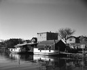
| Date: | 05 05 1963 |
|---|---|
| Description: | View across water towards two fishing boats moored at a dock. |
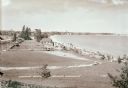
| Date: | 1936 |
|---|---|
| Description: | Crescent Beach campsite with cabins and miniature golf course by Lake Michigan. |
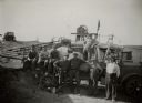
| Date: | 1925 |
|---|---|
| Description: | A Kewaunee County road crew poses in front of gravel crushing machinery. |
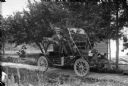
| Date: | 1912 |
|---|---|
| Description: | Although this photograph is unidentified, license plate records in the Wisconsin State Archives indicate that in 1912 the car (a Maxwell) was registered by... |
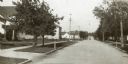
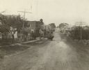
| Date: | 1920 |
|---|---|
| Description: | View down center of street, with dwellings along each side\. |
| Date: | 1936 |
|---|---|
| Description: | Elevated view of Crescent Beach, with campsite with cabins and miniature golf course and other outbuildings. Downtown buildings can be seen in the backgrou... |
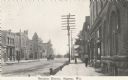
| Date: | 09 20 1922 |
|---|---|
| Description: | Photographic postcard of the business district. Sidewalk view shows pedestrians and a vehicle in the street. Telephone poles and small horsehead shaped hit... |
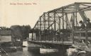
| Date: | 07 19 1920 |
|---|---|
| Description: | Photographic postcard shoreline view of a bridge. Two men in hats are standing on the far right at a railing on the truss bridge looking toward the opposit... |
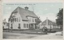
| Date: | 10 07 1930 |
|---|---|
| Description: | Colorized postcard view of the exterior and lawns of the Door-Kewaunee Normal School and its dormitory. Street view of the school with a few small trees l... |

| Date: | 1946 |
|---|---|
| Description: | Map of Kewaunee County, Wisconsin, shows towns, cities and villages, roads and highways, railroads, schools, lighthouses, place names, town divisions, comm... |

| Date: | 1970 |
|---|---|
| Description: | A map of parks of Kewaunee County, Wisconsin, showing the fishing spots, lakes and parks in the area, it also provides a location map of the area. On the ... |
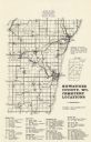
| Date: | 1977 |
|---|---|
| Description: | A map of Kewaunee County, Wisconsin that identifies the locations of 46 cemeteries in the county. The cemeteries are listed by town. |
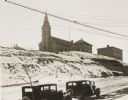
| Date: | 1934 |
|---|---|
| Description: | Terracing on Ellis Street during the winter. Two automobiles are parked alongside the road in the foreground. The terraced hill is snow covered, and a chur... |

| Date: | 1961 |
|---|---|
| Description: | This map shows streets and some points of interest. Kewaunee River and Lake Michigan are both labeled. |

| Date: | 01 07 1958 |
|---|---|
| Description: | View from the Second Street bridge over the icy Ahnapee River towards Lake Michigan. A lighthouse is at the end of a jetty in the far background. Boats are... |
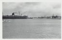
| Date: | 09 15 1960 |
|---|---|
| Description: | View across water towards a carferry named "City of Flint," moored at a dock. There are buildings on the dock on the right. |
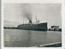
| Date: | 01 07 1958 |
|---|---|
| Description: | View across water to ship moored at a dock. Smoke is coming out of the smokestack. Industrial buildings are across the water on the right. |

| Date: | 1926 |
|---|---|
| Description: | This blueprint manuscript map shows buildings, railroads, and United States property. Water depths shown by soundings, tints, and isolines. |

| Date: | 1937 |
|---|---|
| Description: | This is map 1 from a set of 4 taken from an atlas. The map shows streets, neighborhoods and proposed subdivision. Lake Michigan, Algoma Outer Harbor, the A... |
If you didn't find the material you searched for, our Library Reference Staff can help.
Call our reference desk at 608-264-6535 or email us at: