Filter: Categories of Wisconsin Historical Images
Filter: County of Kewaunee
Filter: Subject of streets
Filter: Categories of Wisconsin Historical Images
Filter: County of Kewaunee
Filter: Subject of streets
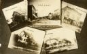
| Date: | 1890 |
|---|---|
| Description: | A collage of scenic views of Luxemburg. |
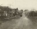
| Date: | 1920 |
|---|---|
| Description: | View down center of street, with dwellings along each side\. |
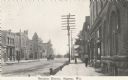
| Date: | 09 20 1922 |
|---|---|
| Description: | Photographic postcard of the business district. Sidewalk view shows pedestrians and a vehicle in the street. Telephone poles and small horsehead shaped hit... |
| Date: | 10 07 1930 |
|---|---|
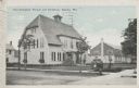
| Description: | Colorized postcard view of the exterior and lawns of the Door-Kewaunee Normal School and its dormitory. Street view of the school with a few small trees l... |

| Date: | 1946 |
|---|---|
| Description: | Map of Kewaunee County, Wisconsin, shows towns, cities and villages, roads and highways, railroads, schools, lighthouses, place names, town divisions, comm... |

| Date: | 1970 |
|---|---|
| Description: | A map of parks of Kewaunee County, Wisconsin, showing the fishing spots, lakes and parks in the area, it also provides a location map of the area. On the ... |

| Date: | 1961 |
|---|---|
| Description: | This map shows streets and some points of interest. Kewaunee River and Lake Michigan are both labeled. |

| Date: | 1926 |
|---|---|
| Description: | This blueprint manuscript map shows buildings, railroads, and United States property. Water depths shown by soundings, tints, and isolines. |

| Date: | 1937 |
|---|---|
| Description: | This is map 1 from a set of 4 taken from an atlas. The map shows streets, neighborhoods and proposed subdivision. Lake Michigan, Algoma Outer Harbor, the A... |
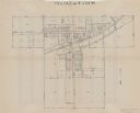
| Date: | 1937 |
|---|---|
| Description: | This is map 2 from a set of 4 taken from an atlas. The map shows streets, railroad tracks, and plots. The back of the map includes an index of residents of... |

| Date: | 1937 |
|---|---|
| Description: | This is map 3 from a set of 4 taken from an atlas. The map shows streets, neighborhoods, lots, and railroad tracks. Lake Michigan, the Kewaunee River, and ... |
If you didn't find the material you searched for, our Library Reference Staff can help.
Call our reference desk at 608-264-6535 or email us at: