 Filter: Categories of Wisconsin Historical Images
Filter: County of Kewaunee
Filter: Creator Name of Unknown
Filter: Community of Kewaunee
Filter: Type of Map or Atlas
Filter: Categories of Wisconsin Historical Images
Filter: County of Kewaunee
Filter: Creator Name of Unknown
Filter: Community of Kewaunee
Filter: Type of Map or Atlas

| Date: | 1840 |
|---|---|
| Description: | This map of Kewaunee shows lot and block numbers, Lake Michigan, and includes a location map showing proposed railroads. The map includes manuscript annota... |
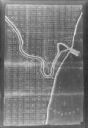
| Date: | 1900 |
|---|---|
| Description: | This photocopy map shows land parcels, block numbers, streets, the Kewaunee River, and Lake Michigan on the far right side. The original map was created ar... |
If you didn't find the material you searched for, our Library Reference Staff can help.
Call our reference desk at 608-264-6535 or email us at:
