 Filter: Categories of Wisconsin Historical Images
Filter: County of Kenosha
Filter: Categories of Wisconsin Historical Images
Filter: County of Kenosha
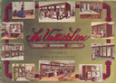
| Date: | 1915 |
|---|---|
| Description: | Front cover featuring ten inset color illustrations of refrigerating machinery, refrigerators and store fixtures in use in the home and in shops. |

| Date: | 1948 |
|---|---|
| Description: | This map shows a list of polling places by ward and precinct in the left margin, a list of assembly districts, and additional handwritten notes. Lake Michi... |

| Date: | 1961 |
|---|---|
| Description: | This is a photocopy of a map in blue line print that shows streets and places of interest. Inscribed in pen, at the bottom of the map, reads: "Sen. Zaborsk... |

| Date: | 1857 |
|---|---|
| Description: | This map was created from a survey made in December 1855 and shows local streets, proposed roads, railroads, the lake shore, bridge wharfs, the basin, the ... |

| Date: | 1910 |
|---|---|
| Description: | This map is a survey of Kenosha Harbor and shows local streets, public buildings, local businesses, and part of Lake Michigan. Included is text on sailing ... |

| Date: | 1857 |
|---|---|
| Description: | This map shows land ownership by name, local streets, wards, buildings, parks, a cemetery, and part of Lake Michigan. Depths are shown by soundings and nor... |
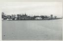
| Date: | 12 09 1957 |
|---|---|
| Description: | Turning basin, view east from ex-Haas property. There is a water tower on the right, and houses, boathouses and other buildings are along the shoreline to ... |

| Date: | |
|---|---|
| Description: | Aerial photograph of the Port of Kenosha and factories, with snow on the ground. There are four ships along the shoreline, and multiple factories on either... |

| Date: | 1945 |
|---|---|
| Description: | Port of Kenosha Transit Warehouse No. 1. There are two ships on the right side, one named "Broom Park." Three men are loading a car onto the ship using a c... |

| Date: | 07 19 1854 |
|---|---|
| Description: | This map shows the shore in 1844, 1850, and 1852, the length of and proposed additions to the pier. Relief is shown by hachures and depths are shown by sou... |

| Date: | 07 19 1854 |
|---|---|
| Description: | This hand-colored map shows the North and South Pier, the North Pier Bridge, the present Channel, and the Channel to be dredged. Lake Michigan and a light ... |

| Date: | 1857 |
|---|---|
| Description: | This map with north oriented toward the lower left shows the United States North and South Piers. Lake shores from 1855, 1856, and 1857 are labeled. Depths... |

| Date: | |
|---|---|
| Description: | Waist-up portrait of Mary Davison Bradford. She was the first women in Wisconsin to serve as a superintendent of schools. She served in Kenosha from 1910-1... |
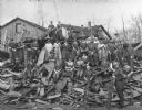
| Date: | 1918 |
|---|---|
| Description: | A group of women employees of the N.R. Allen Tannery posing with a pile of tan bark. |

| Date: | 1959 |
|---|---|
| Description: | This map shows public access sites, public beaches and parks, other public shorelines, boat liveries, public hunting and fishing grounds, railroads, roads,... |
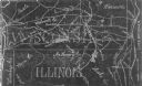
| Date: | 1954 |
|---|---|
| Description: | This photocopy map shows a early sketch of the settlement Southport. Rivers, lakes, other settlements, county boundaries, and roads are labeled. A portion ... |

| Date: | 1926 |
|---|---|
| Description: | This blueprint map shows the harbor at Kenosha, also showing buildings surrounding the harbor, roads, and railroads. Original caption in red states: "Areas... |

| Date: | 1958 |
|---|---|
| Description: | Daniel J. Travanti smiles as he stands outside on a lawn. He is wearing a suit with a flower pinned to his lapel and is dressed up for his high school grad... |
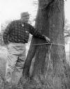
| Date: | 1962 |
|---|---|
| Description: | Noted Kenosha County "citizen conservationist" and environmentalist Phil H. Sander (1906-2006) holding a tape measure around the trunk of the Rhodesdale ba... |
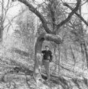
| Date: | 01 1965 |
|---|---|
| Description: | Phil Sander (1906-2006), noted Kenosha conservationist and environmentalist, posing next to a "trail tree" which has two right-angled curves in its trunk. ... |
If you didn't find the material you searched for, our Library Reference Staff can help.
Call our reference desk at 608-264-6535 or email us at: