 Filter: Categories of Wisconsin Historical Images
Filter: County of Kenosha
Filter: Year of 1900-1999
Filter: Categories of Wisconsin Historical Images
Filter: County of Kenosha
Filter: Year of 1900-1999

| Date: | 1905 |
|---|---|
| Description: | This pictorial representation of part of Lake Winnebago and the Fox River in 1703, showing interactions between white beaver hunters and the Iroquois is ta... |

| Date: | 1973 |
|---|---|
| Description: | Map shows sections, trails, roads, and locations of ancient burial grounds, hills, groves, and settlers. Printed in brown ink. |

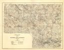
| Date: | 1910 |
|---|---|
| Description: | Map shows routes, post offices, churches, schools, houses, and roads on the rural delivery service route in blue lines. An explanation key appears on the l... |
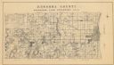
| Date: | 1934 |
|---|---|
| Description: | A land inventory map of Kenosha County. The top left features a legend of "Land Cover" and "Roads and Other Improvements". Lake Michigan is labelled to the... |
| Date: | 1929 |
|---|---|
| Description: | Map of the Menominee Indian Reservation. Legend reads: "Topographic and cultural data were obtained from field notes of a timber cruise and land classifica... |

| Date: | 03 09 1911 |
|---|---|
| Description: | Man standing in front of a Chicago and Northwestern railroad boxcar sitting on railroad tracks. The sides of the car are splintered, destroyed by an explos... |

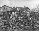
| Date: | 03 09 1911 |
|---|---|
| Description: | A man stands on a foundation among the debris of the aftermath of a powder explosion. Around the man are pieces of corrugated metal, machinery and wood. In... |

| Date: | 03 09 1911 |
|---|---|
| Description: | View looking down of a man standing among rubble and other debris at the bottom of a "300 ft. by 150 ft." hole in the ground from a powder explosion. |
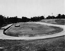
| Date: | 06 23 1936 |
|---|---|
| Description: | Velodrome at Washington Park with a "USA Work Program WPA" sign in the infield. Sprinklers are watering the grass. |

| Date: | 1945 |
|---|---|
| Description: | This map shows wards and precincts and includes a list of polling places by ward and precinct. The map reads: "Keep this Map . . . It Gives the Location of... |

| Date: | 1948 |
|---|---|
| Description: | This map shows wards and precincts and includes a list of polling places by ward and precinct. The map reads: "Keep this Map . . . It Gives the Location of... |

| Date: | 1953 |
|---|---|
| Description: | This map is a blue line print and shows streets as well as some points of interest. |

| Date: | 1955 |
|---|---|
| Description: | This map shows wards and precincts and includes list of polling places by ward and precinct, and list of State Assembly districts. |
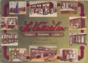
| Date: | 1915 |
|---|---|
| Description: | Front cover featuring ten inset color illustrations of refrigerating machinery, refrigerators and store fixtures in use in the home and in shops. |

| Date: | 1948 |
|---|---|
| Description: | This map shows a list of polling places by ward and precinct in the left margin, a list of assembly districts, and additional handwritten notes. Lake Michi... |

| Date: | 1961 |
|---|---|
| Description: | This is a photocopy of a map in blue line print that shows streets and places of interest. Inscribed in pen, at the bottom of the map, reads: "Sen. Zaborsk... |

| Date: | 1910 |
|---|---|
| Description: | This map is a survey of Kenosha Harbor and shows local streets, public buildings, local businesses, and part of Lake Michigan. Included is text on sailing ... |
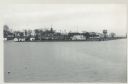
| Date: | 12 09 1957 |
|---|---|
| Description: | Turning basin, view east from ex-Haas property. There is a water tower on the right, and houses, boathouses and other buildings are along the shoreline to ... |

| Date: | 1945 |
|---|---|
| Description: | Port of Kenosha Transit Warehouse No. 1. There are two ships on the right side, one named "Broom Park." Three men are loading a car onto the ship using a c... |
| Date: | 1918 |
|---|---|
| Description: | A group of women employees of the N.R. Allen Tannery posing with a pile of tan bark. |
If you didn't find the material you searched for, our Library Reference Staff can help.
Call our reference desk at 608-264-6535 or email us at: