Filter: Categories of Wisconsin Historical Images
Filter: County of Kenosha
Filter: Year of 1800-1899
Filter: Subject of water
Filter: Categories of Wisconsin Historical Images
Filter: County of Kenosha
Filter: Year of 1800-1899
Filter: Subject of water
| Date: | 1878 |
|---|---|
| Description: | View from shoreline of a large crowd on a pier waiting for a crowded steam excursion boat. |

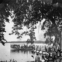
| Date: | 1878 |
|---|---|
| Description: | People seated in a small steamboat tied at a pier on a lake. A flag flies from the bow and there is a two-story frame house on the shore. This photograph m... |
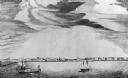
| Date: | 10 1844 |
|---|---|
| Description: | A variant of a wood engraving dated October, 1844. Incorporated as the villige of Southport in 1841 (so-named because it was the southern-most natural harb... |
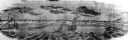
| Date: | 10 1844 |
|---|---|
| Description: | View from a pile-driver on the north pier of the community then known as Southport. The pier visible at left center, constructed between 1840-1842, was th... |

| Date: | 10 19 1836 |
|---|---|
| Description: | This 1836 manuscript map shows the sections, windfalls, marshes, streams, prairies, acreages, and former mouth of the Pike River in what is now the eastern... |

| Date: | 1890 |
|---|---|
| Description: | View from the shore of Kenosha's North Pier and lighthouse. Waves are breaking on the shore of Lake Michigan. |

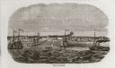
| Date: | 1871 |
|---|---|
| Description: | Engraved view of Kenosha harbor. A group of men fish from a pier in the foreground while several boats float through the harbor. A tug is pulling a large s... |

| Date: | 08 17 1874 |
|---|---|
| Description: | This manuscript drawing provides a side elevation, plan, and perspective view for a proposed lock on the Fox River. |

| Date: | 1892 |
|---|---|
| Description: | This map shows the dams and locks of the Fox River between Neenah, in Winnebago County, Wisconsin, and Kaukauna, in Outagamie County. The cities and villag... |

| Date: | 1850 |
|---|---|
| Description: | A map which includes the ink and pencil annotations showing the sections, sold parcels of land, and streams and lakes on a printed township base map for To... |

| Date: | 1855 |
|---|---|
| Description: | This map has relief shown by hachures and soundings and shows local streets, proposed roads, railroads, bridge wharfs, basin, north arm, and west arm of Ke... |

| Date: | 1857 |
|---|---|
| Description: | This map was created from a survey made in December 1855 and shows local streets, proposed roads, railroads, the lake shore, bridge wharfs, the basin, the ... |

| Date: | 1857 |
|---|---|
| Description: | This map shows land ownership by name, local streets, wards, buildings, parks, a cemetery, and part of Lake Michigan. Depths are shown by soundings and nor... |

| Date: | 07 19 1854 |
|---|---|
| Description: | This map shows the shore in 1844, 1850, and 1852, the length of and proposed additions to the pier. Relief is shown by hachures and depths are shown by sou... |

| Date: | 07 19 1854 |
|---|---|
| Description: | This hand-colored map shows the North and South Pier, the North Pier Bridge, the present Channel, and the Channel to be dredged. Lake Michigan and a light ... |

| Date: | 1857 |
|---|---|
| Description: | This map with north oriented toward the lower left shows the United States North and South Piers. Lake shores from 1855, 1856, and 1857 are labeled. Depths... |
If you didn't find the material you searched for, our Library Reference Staff can help.
Call our reference desk at 608-264-6535 or email us at: