Filter: Categories of Wisconsin Historical Images
Filter: County of Kenosha
Filter: Subject of transportation
Filter: Year of 1800-1899
Filter: Categories of Wisconsin Historical Images
Filter: County of Kenosha
Filter: Subject of transportation
Filter: Year of 1800-1899
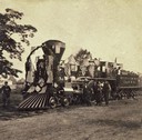
| Date: | 07 04 1869 |
|---|---|
| Description: | The Camilla, a wood-burning locomotive that belonged to the Chicago & Northwestern Railway. The locomotive is decorated for the 4th of July, 1869. |
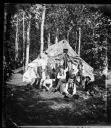
| Date: | 1878 |
|---|---|
| Description: | Group of men outside tent with "The Boss" sign above door and labels on some of the fellows' shirts saying, "CTC," an abbreviation for the Chicago Travelin... |
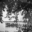
| Date: | 1878 |
|---|---|
| Description: | View from shoreline of a large crowd on a pier waiting for a crowded steam excursion boat. |

| Date: | 1878 |
|---|---|
| Description: | People seated in a small steamboat tied at a pier on a lake. A flag flies from the bow and there is a two-story frame house on the shore. This photograph m... |
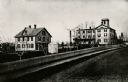
| Date: | 1860 |
|---|---|
| Description: | Elevated view of the Durkee House built by Charles Durkee in 1843. |
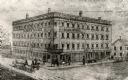
| Date: | 1880 |
|---|---|
| Description: | The Kenosha water cure on the corner of N. Main and Grand Avenue. It was built in the 1840's for educational and religious purposes. It burned down in 1900... |

| Date: | 1870 |
|---|---|
| Description: | View across intersection towards Kimball's Hall, one of the first brick buildings in Kenosha. A sign on the right side of the building reads: "Dewey & Sinc... |
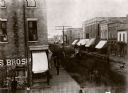
| Date: | 1872 |
|---|---|
| Description: | Elevated view looking down Main Street. There are horse-drawn vehicles, and pedestrians are walking on the street and sidewalks. |

| Date: | 05 12 1898 |
|---|---|
| Description: | View down center of street with shops and stores on either side of Main Street. |
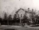
| Date: | 1860 |
|---|---|
| Description: | The home of I.G. Merrill on the corner of Ann Street (now called Sheridan Road) and Prairie Avenue. A person is standing in front of the fence at the corne... |

| Date: | 1879 |
|---|---|
| Description: | The home of I.G. Merrill, located on the corner of Ann Street (now called Sheridan Road) and Prairie Avenue, in the winter. |
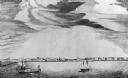
| Date: | 10 1844 |
|---|---|
| Description: | A variant of a wood engraving dated October, 1844. Incorporated as the villige of Southport in 1841 (so-named because it was the southern-most natural harb... |
| Date: | 10 1844 |
|---|---|
| Description: | View from a pile-driver on the north pier of the community then known as Southport. The pier visible at left center, constructed between 1840-1842, was th... |

| Date: | 1890 |
|---|---|
| Description: | View from the shore of Kenosha's North Pier and lighthouse. Waves are breaking on the shore of Lake Michigan. |

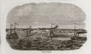
| Date: | 1871 |
|---|---|
| Description: | Engraved view of Kenosha harbor. A group of men fish from a pier in the foreground while several boats float through the harbor. A tug is pulling a large s... |

| Date: | 08 17 1874 |
|---|---|
| Description: | This manuscript drawing provides a side elevation, plan, and perspective view for a proposed lock on the Fox River. |

| Date: | 1892 |
|---|---|
| Description: | This map shows the dams and locks of the Fox River between Neenah, in Winnebago County, Wisconsin, and Kaukauna, in Outagamie County. The cities and villag... |

| Date: | 1861 |
|---|---|
| Description: | Depths shown by soundings. Shows township and sections, landownership and acreages, roads, railroads, and buildings. "Entered according to Act of Congress ... |
If you didn't find the material you searched for, our Library Reference Staff can help.
Call our reference desk at 608-264-6535 or email us at: