 Filter: Categories of Wisconsin Historical Images
Filter: County of Kenosha
Filter: Subject of transportation
Filter: Year of 1900-1999
Filter: Year of 1950-1959
Filter: Categories of Wisconsin Historical Images
Filter: County of Kenosha
Filter: Subject of transportation
Filter: Year of 1900-1999
Filter: Year of 1950-1959

| Date: | 1953 |
|---|---|
| Description: | This map is a blue line print and shows streets as well as some points of interest. |

| Date: | 1959 |
|---|---|
| Description: | This map shows public access sites, public beaches and parks, other public shorelines, boat liveries, public hunting and fishing grounds, railroads, roads,... |
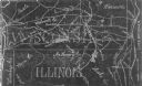
| Date: | 1954 |
|---|---|
| Description: | This photocopy map shows a early sketch of the settlement Southport. Rivers, lakes, other settlements, county boundaries, and roads are labeled. A portion ... |

| Date: | 1958 |
|---|---|
| Description: | Daniel J. Travanti smiles as he stands outside on a lawn. He is wearing a suit with a flower pinned to his lapel and is dressed up for his high school grad... |

| Date: | 09 1955 |
|---|---|
| Description: | Sky and clouds above Highway 43, west of Kenosha. Guard rails line the highway on both sides and trees can be seen on the left side. |
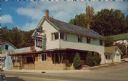
| Date: | 1950 |
|---|---|
| Description: | Text on reverse reads: "Fairview Dining Room and Cocktail Lounge. Twin Lakes, Wis. Southern Wisconsin's finest dining spot featuring roast duck and lobster... |
If you didn't find the material you searched for, our Library Reference Staff can help.
Call our reference desk at 608-264-6535 or email us at: