 Filter: Categories of Wisconsin Historical Images
Filter: County of Kenosha
Filter: Type of Map or Atlas
Filter: Creator Name of Unknown
Filter: Categories of Wisconsin Historical Images
Filter: County of Kenosha
Filter: Type of Map or Atlas
Filter: Creator Name of Unknown

| Date: | 10 19 1836 |
|---|---|
| Description: | This 1836 manuscript map shows the sections, windfalls, marshes, streams, prairies, acreages, and former mouth of the Pike River in what is now the eastern... |

| Date: | 1850 |
|---|---|
| Description: | A map which includes the ink and pencil annotations showing the sections, sold parcels of land, and streams and lakes on a printed township base map for To... |
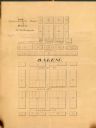
| Date: | 1858 |
|---|---|
| Description: | Map is ink and pencil on paper. Map showing Leonard's Addition to Salem Wisconsin in Kenosha County. The plats are numbered. |

| Date: | 1878 |
|---|---|
| Description: | An etching of the farm and residence of Mrs. C.E. Packman and her son. |
If you didn't find the material you searched for, our Library Reference Staff can help.
Call our reference desk at 608-264-6535 or email us at: