Filter: Categories of Wisconsin Historical Images
Filter: County of Juneau
Filter: Year of 1900-1999
Filter: Year of 1950-1959
Filter: Categories of Wisconsin Historical Images
Filter: County of Juneau
Filter: Year of 1900-1999
Filter: Year of 1950-1959

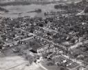
| Date: | 1953 |
|---|---|
| Description: | Aerial view of Wonewoc with hills or bluffs in the foreground on the right. |

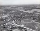
| Date: | 1953 |
|---|---|
| Description: | An aerial view of Wonewoc showing central businesses and a railroad. |

| Date: | 11 1957 |
|---|---|
| Description: | Photograph taken by the State Highway Department to show the condition of curbs and gutters along STH 12 in Mauston, also documenting the original brick su... |
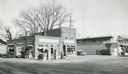
| Date: | 1957 |
|---|---|
| Description: | Skelly service station, restaurant, and motel located along STH 12 in Mauston, Wisconsin. |

| Date: | 1957 |
|---|---|
| Description: | Aerial view of town including water tower, city streets, houses, and other buildings. |
| Date: | 1957 |
|---|---|
| Description: | Aerial view of town including houses, water tower, city streets and buildings. |

| Date: | 1950 |
|---|---|
| Description: | Aerial view of the Highway 21 bridge and Petenwell Dam on the Wisconsin River. |

| Date: | 10 05 1957 |
|---|---|
| Description: | Informal outdoor portrait of John H. Brokopp. |

| Date: | 1958 |
|---|---|
| Description: | This blue line print map shows lot and block numbers and dimensions, additions, and some landownership. The Lawrence River is labeled. |

| Date: | 1950 |
|---|---|
| Description: | View of a cave in a bluff, with a man standing in the entrance. Caption reads: "Cave at Mill Bluff, Mauston, Wis." |

| Date: | 12 31 1957 |
|---|---|
| Description: | Patrick J. Donnelly (left) on his last day of work after serving as conductor with the North Western Railway for 52 years. K.M. Prenot (right), a brakeman ... |

| Date: | 1950 |
|---|---|
| Description: | Castle Rock, surrounded by trees and a meadow. The geological feature is near Volk Field Air National Guard Base. |
If you didn't find the material you searched for, our Library Reference Staff can help.
Call our reference desk at 608-264-6535 or email us at: