Filter: Categories of Wisconsin Historical Images
Filter: County of Juneau
Filter: Subject of rivers
Filter: Categories of Wisconsin Historical Images
Filter: County of Juneau
Filter: Subject of rivers
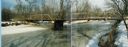
| Date: | 1987 |
|---|---|
| Description: | Ninth Street Bridge across the Yellow River in the Town of Armenia, Juneau County, Wisconsin. |
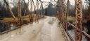
| Date: | 1982 |
|---|---|
| Description: | Bridge over the Lemonweir River in the Town of Orange, Juneau County. |
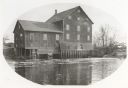
| Date: | 1885 |
|---|---|
| Description: | Lemonweir River flour mill built in 1852 and torn down in 1943. Mill and site were purchased in 1926 by the Wisconsin Power and Light Company for a power p... |
| Date: | 1905 |
|---|---|
| Description: | Petenwell Bridge. Caption reads: "Pete-eu-nell Bridge, Necedah, Wis." |

| Date: | 1950 |
|---|---|
| Description: | Aerial view of the Highway 21 bridge and Petenwell Dam on the Wisconsin River. |

| Date: | 1926 |
|---|---|
| Description: | This hand-colored blueprint map shows landowners in part of T15N, R5E in Juneau County. North is oriented to the right. |

| Date: | 03 16 1949 |
|---|---|
| Description: | Aerial view of Mauston, Wisconsin. |

| Date: | 1920 |
|---|---|
| Description: | Slightly elevated view towards a man rowing his boat along the Lemonweir River. Caption reads: "Scene on Lemonweir River — Oak & Maple Grove Resort — Maust... |

| Date: | 1935 |
|---|---|
| Description: | Map of Juneau County showing area zoned for reforestation shaded in red. |
| Date: | 1965 |
|---|---|
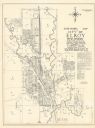
| Description: | Shows city limits, plat of town, local streets, railroads, and Baraboo River. "Revised by Mid-State Associates, Baraboo, Wisconsin, April 6, 1965" Upper ri... |

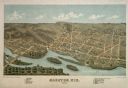
| Date: | 1913 |
|---|---|
| Description: | A bird's eye view of the central business district. A river winding through the background. A building with a belfry in the foreground. |

| Date: | |
|---|---|
| Description: | A view of the Wonewoc Mill Company where they manufacture White Swan Flour. Sacks of flour and two men sitting on the loading dock. A woman walking away on... |
| Date: | 1884 |
|---|---|
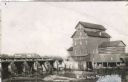
| Description: | View across river of the Model Roller Mills, with the date 1884, with a railroad trestle is on the left. The mill wheel is turning. |

| Date: | 1915 |
|---|---|
| Description: | An Paige automobile with six people in it is stopped outside the toll house on the Juneau County side at the foot of the rock. There is a lantern and a roc... |

| Date: | 1879 |
|---|---|
| Description: | This bird’s-eye-view map is a photostat copy of the orginal and is indexed for points of interest. Streets are labeled as well as the Barbaoo River. |

| Date: | |
|---|---|
| Description: | This plat map shows numbered blocks and lots, local streets, the La Crosse and Milwaukee Railroad, and part of the Lemonwier [i.e. Lemonweir] River. |

| Date: | 1958 |
|---|---|
| Description: | This blue line print map shows lot and block numbers and dimensions, additions, and some landownership. The Lawrence River is labeled. |

| Date: | |
|---|---|
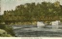
| Description: | View of the Baraboo River and the rock formations on both sides. Caption reads: "Elroy, Wis." |

| Date: | 1909 |
|---|---|
| Description: | View across river towards a steel bridge with stone pylons on the Wisconsin River at Lone Rock. A horse-drawn wagon with two men is crossing over to the ot... |
If you didn't find the material you searched for, our Library Reference Staff can help.
Call our reference desk at 608-264-6535 or email us at: