 Filter: Categories of Wisconsin Historical Images
Filter: County of Juneau
Filter: Subject of land
Filter: Categories of Wisconsin Historical Images
Filter: County of Juneau
Filter: Subject of land

| Date: | 1879 |
|---|---|
| Description: | This bird’s-eye-view map is a photostat copy of the orginal and is indexed for points of interest. Streets are labeled as well as the Barbaoo River. |

| Date: | |
|---|---|
| Description: | This plat map shows numbered blocks and lots, local streets, the La Crosse and Milwaukee Railroad, and part of the Lemonwier [i.e. Lemonweir] River. |

| Date: | 1958 |
|---|---|
| Description: | This blue line print map shows lot and block numbers and dimensions, additions, and some landownership. The Lawrence River is labeled. |
| Date: | |
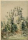
|---|---|
| Description: | Watercolor painting of Mill Bluff, now part of Mill Bluff State Park. |
| Date: | 1917 |
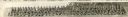
|---|---|
| Description: | Panoramic group portrait of Company "K" Fourth Wisconsin Infantry. In the background is a rock formation, one of several in the area, with trees. The soldi... |

| Date: | 10 10 1978 |
|---|---|
| Description: | Margaret Kocher and Richard Retzlaff of Wonewoc posing in front of their 100-year-old barn. "People are always saying we should tear it down because it's t... |

| Date: | 10 20 1978 |
|---|---|
| Description: | View across field towards a wagon stacked with bales of hay near a barn and a silo at the base of a bluff near Union Center. |
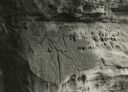
| Date: | |
|---|---|
| Description: | Figures carved in stone at Twin Bluffs petroglyph site. |

| Date: | |
|---|---|
| Description: | Exterior view of the Elroy Hospital. The two-story building has a wrap-around porch. In the background is a field with piles of harvested grain. Caption re... |

| Date: | |
|---|---|
| Description: | Elevated view from hill of a farm and the surrounding landscape. Hills are in the distance. Caption reads: "Elroy, Wis." |

| Date: | |
|---|---|
| Description: | View of the Baraboo River and the rock formations on both sides. Caption reads: "Elroy, Wis." |
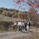
| Date: | 1967 |
|---|---|
| Description: | A group of men and women walking along a gravel path. |

| Date: | 1917 |
|---|---|
| Description: | Elevated view of tents at Camp Douglas. A few soldiers are among the tents. A large, rocky hill is in the background on the right. Caption reads: "Birdseye... |

| Date: | 1950 |
|---|---|
| Description: | View of a cave in a bluff, with a man standing in the entrance. Caption reads: "Cave at Mill Bluff, Mauston, Wis." |

| Date: | |
|---|---|
| Description: | Photographic postcard view looking up at the rock formation. Caption reads: "Pollard Rock, Mauston, Wis." |

| Date: | |
|---|---|
| Description: | View across water towards the bluff on the river. Caption reads: "Castle Rock on Wisconsin River, Mauston, Wis." |

| Date: | |
|---|---|
| Description: | View of Steamboat Rock, a rock formation near Mauston. Caption reads: "Steamboat Rock, Mauston, Wis." |

| Date: | |
|---|---|
| Description: | View of Coon Rock, a pillar rock formation near Mauston. Caption reads: "Coon Rock, Mauston, Wis." |

| Date: | 1904 |
|---|---|
| Description: | View across a body of water toward several buildings along a shoreline. Caption reads: "Main Street, Necedah, Wis. looking south from the residence of Dr. ... |
| Date: | |
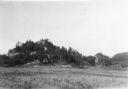
|---|---|
| Description: | View of a rock formation with trees growing on and around it. Fence posts, power lines, and some farm buildings are nearby on the right. Caption reads: "Ro... |
If you didn't find the material you searched for, our Library Reference Staff can help.
Call our reference desk at 608-264-6535 or email us at: