Filter: Categories of Wisconsin Historical Images
Filter: County of Juneau
Filter: Subject of cities and towns
Filter: Subject of water
Filter: Categories of Wisconsin Historical Images
Filter: County of Juneau
Filter: Subject of cities and towns
Filter: Subject of water
| Date: | 1908 |
|---|---|
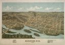
| Description: | View from shoreline toward the lower part of a dam. Caption reads: "Dam in Elroy, Wis." |
| Date: | 1885 |
|---|---|
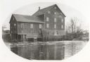
| Description: | Lemonweir River flour mill built in 1852 and torn down in 1943. Mill and site were purchased in 1926 by the Wisconsin Power and Light Company for a power p... |
| Date: | 1905 |
|---|---|
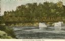
| Description: | Petenwell Bridge. Caption reads: "Pete-eu-nell Bridge, Necedah, Wis." |

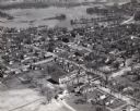
| Date: | 1957 |
|---|---|
| Description: | Aerial view of town including water tower, city streets, houses, and other buildings. |
| Date: | 1957 |
|---|---|
| Description: | Aerial view of town including houses, water tower, city streets and buildings. |

| Date: | 1950 |
|---|---|
| Description: | Aerial view of the Highway 21 bridge and Petenwell Dam on the Wisconsin River. |

| Date: | 1926 |
|---|---|
| Description: | This hand-colored blueprint map shows landowners in part of T15N, R5E in Juneau County. North is oriented to the right. |

| Date: | 03 16 1949 |
|---|---|
| Description: | Aerial view of Mauston, Wisconsin. |
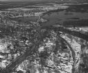
| Date: | 04 16 1949 |
|---|---|
| Description: | Aerial view of Necedah, Wisconsin, and Petenwell Lake behind Petenwell Dam on the Wisconsin River. |

| Date: | 1935 |
|---|---|
| Description: | Map of Juneau County showing area zoned for reforestation shaded in red. |
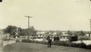
| Date: | |
|---|---|
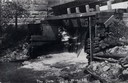
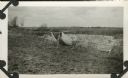
| Description: | View looking north across the Highway 21 bridge at Necedah Lake. A man, likely a Resettlement Administration worker, poses in the grass in the foreground. |
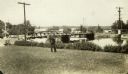
| Date: | 1935 |
|---|---|
| Description: | View looking north across the Highway 21 bridge at Necedah Lake. A man, likely a Resettlement Administration worker, stands holding a pipe in the foregroun... |
| Date: | 1965 |
|---|---|
| Description: | Shows city limits, plat of town, local streets, railroads, and Baraboo River. "Revised by Mid-State Associates, Baraboo, Wisconsin, April 6, 1965" Upper ri... |

| Date: | 1913 |
|---|---|
| Description: | A bird's eye view of the central business district. A river winding through the background. A building with a belfry in the foreground. |

| Date: | |
|---|---|
| Description: | A view of the Wonewoc Mill Company where they manufacture White Swan Flour. Sacks of flour and two men sitting on the loading dock. A woman walking away on... |
| Date: | |
|---|---|
| Description: | The Civilian Conservation Corps dam built at Camp Petenwell near Necedah. |

| Date: | 1876 |
|---|---|
| Description: | A hand-colored map on six sheets, this map of Juneau County indicates the locations of townships and sections, landowners and acreages, roads, wagon roads,... |

| Date: | 1879 |
|---|---|
| Description: | This bird’s-eye-view map is a photostat copy of the orginal and is indexed for points of interest. Streets are labeled as well as the Barbaoo River. |

| Date: | |
|---|---|
| Description: | This plat map shows numbered blocks and lots, local streets, the La Crosse and Milwaukee Railroad, and part of the Lemonwier [i.e. Lemonweir] River. |
If you didn't find the material you searched for, our Library Reference Staff can help.
Call our reference desk at 608-264-6535 or email us at: