 Filter: Categories of Wisconsin Historical Images
Filter: County of Juneau
Filter: Type of Photograph
Filter: Subject of transportation
Filter: Categories of Wisconsin Historical Images
Filter: County of Juneau
Filter: Type of Photograph
Filter: Subject of transportation
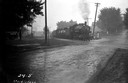
| Date: | 09 1936 |
|---|---|
| Description: | Chicago & Northwestern Railroad train crossing the Elroy-New Lisbon Road (Highway 80). |
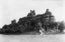
| Date: | 1937 |
|---|---|
| Description: | Castle Rock. Castle Rock is an example of a monadnock or inselberg, a geological formation common in northern and central Wisconsin. |
| Date: | 1910 |
|---|---|
| Description: | Elevated view of Camp Williams Town, with many houses. In the background are bluffs. |
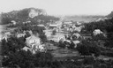
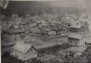
| Date: | 1907 |
|---|---|
| Description: | Panoramic view looking down Main Street, with horses and carriages parked outside the storefronts on the street. |

| Date: | 1858 |
|---|---|
| Description: | An ambrotype of Wonewoc. A road and fence is in the foreground, with houses beyond. A tree-lined hill is in the background. |

| Date: | 1953 |
|---|---|
| Description: | Aerial view of Wonewoc with hills or bluffs in the foreground on the right. |
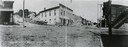
| Date: | 1886 |
|---|---|
| Description: | Elevated view of houses and buildings in Wonewoc. |

| Date: | 1953 |
|---|---|
| Description: | An aerial view of Wonewoc showing central businesses and a railroad. |
| Date: | 1987 |
|---|---|
| Description: | Ninth Street Bridge across the Yellow River in the Town of Armenia, Juneau County, Wisconsin. |
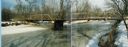
| Date: | 1989 |
|---|---|
| Description: | View from the 20th Street Bridge across the Little Yellow River, Town of Necedah, Juneau County. Several dirt covered roads lead into a wooded area. |

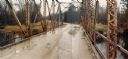
| Date: | 1985 |
|---|---|
| Description: | View of the approach to the One Mile Creek bridge on County N, Juneau County. |
| Date: | 1982 |
|---|---|
| Description: | Bridge over the Lemonweir River in the Town of Orange, Juneau County. |
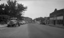
| Date: | |
|---|---|
| Description: | Main Street (State Highway 80) in Necedah, Juneau County, looking south. Automobiles are parked at an angle on one side of the street. |

| Date: | 1968 |
|---|---|
| Description: | Standard Oil station with road work taking place in the foreground. Included in the view is a telephone booth. |

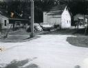
| Date: | 06 1980 |
|---|---|
| Description: | Identified only as the intersection of Flowage Road and State Highway 173 in Juneau County, this image probably shows the entrance to the Meadow Valley Flo... |
| Date: | 08 03 1973 |
|---|---|
| Description: | View of an Elroy alley from Cedar Street. The deteriorating garage in the foreground is of an unusual design. |

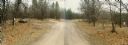
| Date: | 04 07 1988 |
|---|---|
| Description: | Panoramic view over Juneau County Highway Q, about four miles south of the entrance to Buckhorn State Park. |
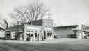
| Date: | 1957 |
|---|---|
| Description: | Skelly service station, restaurant, and motel located along STH 12 in Mauston, Wisconsin. |

| Date: | 12 03 1980 |
|---|---|
| Description: | Giese residence located on State Highway 80/82 in Union Center taken by the State Department of Transportation to illustrate the pond ditch drainage on the... |
If you didn't find the material you searched for, our Library Reference Staff can help.
Call our reference desk at 608-264-6535 or email us at:
