Filter: Categories of Wisconsin Historical Images
Filter: County of Jefferson
Filter: Year of 1800-1899
Filter: Year of 1880-1889
Filter: Categories of Wisconsin Historical Images
Filter: County of Jefferson
Filter: Year of 1800-1899
Filter: Year of 1880-1889

| Date: | 1880 |
|---|---|
| Description: | Bird's-eye view of Jefferson on the Rock River. |

| Date: | 1885 |
|---|---|
| Description: | Bird's-eye view of Watertown with indexed points of interest. |
| Date: | 1885 |
|---|---|
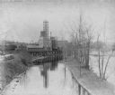
| Description: | View of the Rockdale mill, a grist and sawmill built in 1847 by Thomas and Nathan Van Horn. A group of people are standing on a sidewalk or loading dock on... |
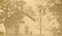
| Date: | 1880 |
|---|---|
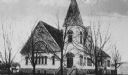
| Description: | View of the First Methodist Church. |
| Date: | 1885 |
|---|---|
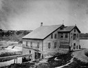
| Description: | View of the Methodist Church and parsonage, with Reverend Elvardo Cyrus Potter standing outside with his daughter, Grace. |
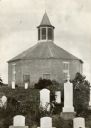
| Date: | 1885 |
|---|---|
| Description: | Norwegian Octagon church, built in 1852 and torn down about 1891 or 1892. |
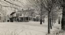
| Date: | 1885 |
|---|---|
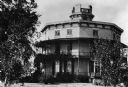
| Description: | The Faville home, built about 1850 on 120 acres bought from the government in 1844. As late as 1922 the home was still in the Faville family. The additions... |
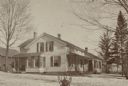
| Date: | 1885 |
|---|---|
| Description: | The Faville home, built about 1850 on 120 acres bought from the government in 1844. As late as 1922 the home was still in the Faville family. The additions... |
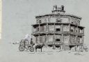
| Date: | 1885 |
|---|---|
| Description: | Drawing of the Octagon House with a horse and carriage in the foreground. |

| Date: | 09 1884 |
|---|---|
| Description: | Sanborn map of Fort Atkinson including Barrie, Germany, and North Water Streets. |

| Date: | 09 1884 |
|---|---|
| Description: | Sanborn map of Fort Atkinson including South Water and Milwaukee Streets. |

| Date: | 1887 |
|---|---|
| Description: | This map shows landownership, lot and block numbers, wards, cemeteries, and the high school. The map has been removed from Page’s Atlas of Jefferson County... |
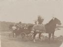
| Date: | 1889 |
|---|---|
| Description: | A family posing in an open carriage pulled by a matched team of horses on the shore of Rock Lake near Lake Mills. A handwritten caption identifies the fami... |

| Date: | 10 1884 |
|---|---|
| Description: | A Sanborn map of Watertown, including the City Brewery and the Rock River. |
If you didn't find the material you searched for, our Library Reference Staff can help.
Call our reference desk at 608-264-6535 or email us at: