 Filter: Categories of Wisconsin Historical Images
Filter: County of Jefferson
Filter: Year of 1800-1899
Filter: Year of 1840-1849
Filter: Categories of Wisconsin Historical Images
Filter: County of Jefferson
Filter: Year of 1800-1899
Filter: Year of 1840-1849
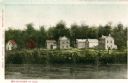
| Date: | 1842 |
|---|---|
| Description: | View across the river towards several residences on the opposite shoreline. Caption reads: "Watertown in 1842." |
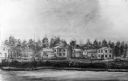
| Date: | 1841 |
|---|---|
| Description: | View across the river towards several residences on the opposite shoreline. |

| Date: | 1840 |
|---|---|
| Description: | Map shows three Wisconsin territories, Jefferson, Waukesha, and Milwaukee. Map is ink, pencil, and watercolor on paper. Relief shown by hachures. |
If you didn't find the material you searched for, our Library Reference Staff can help.
Call our reference desk at 608-264-6535 or email us at:
