 Filter: Categories of Wisconsin Historical Images
Filter: County of Jefferson
Filter: Type of Map or Atlas
Filter: Categories of Wisconsin Historical Images
Filter: County of Jefferson
Filter: Type of Map or Atlas

| Date: | |
|---|---|
| Description: | A brochure and map of Jefferson County, Wisconsin, that includes illustrations and a location map. Descriptions of points of interest are printed on the op... |

| Date: | |
|---|---|
| Description: | A road map of Jefferson County, Wisconsin, shows different types of roads, townships and sections, towns, railroads, and cities and villages. Cemetery loca... |

| Date: | |
|---|---|
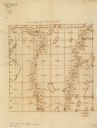
| Description: | An ink and watercolor on tracing map showing the sections and surveyed lots in the vicinity of the Rock and Crawfish rivers in the central and eastern port... |
| Date: | 1860 |
|---|---|
| Description: | This manuscript map shows the surveyed areas of the Town of Aztalan, Jefferson County, Wisconsin. Acreage of the surveyed parcels is given and lakes and st... |

| Date: | 1870 |
|---|---|
| Description: | Bird’s-eye view map. "Looking north east." Indexed for points of interest. Shows homes, businesses, and the Bark and Rock River. Streets running west to ea... |

| Date: | 1920 |
|---|---|
| Description: | Shows ward boundaries, corporation limits, plat of town, land ownership by name, local streets, parks, railroads, and parts of Rock River. Wards appear in ... |

| Date: | 1947 |
|---|---|
| Description: | Lower left hand corner features a legend. "Drawn 1938, revised 1947." Shows water mains, hydrants, corporation limits, city ward divisions, fire proof buil... |

| Date: | 1976 |
|---|---|
| Description: | Includes index of streets and of local businesses. Shows location of Citizens State Bank, roads, highways, railroads, parks, cemeteries, and city sanitary ... |

| Date: | 1840 |
|---|---|
| Description: | Map shows three Wisconsin territories, Jefferson, Waukesha, and Milwaukee. Map is ink, pencil, and watercolor on paper. Relief shown by hachures. |

| Date: | 1911 |
|---|---|
| Description: | Map shows in blue roads, railroads, post offices, schools, houses, churches, and routes. The map includes a chart of "Explanation" that acts as a legend. T... |

| Date: | 1872 |
|---|---|
| Description: | Map shows townships and sections, landownership, roads, railroads, churches, schools, and cemeteries. The map includes business directories of Watertown, J... |
| Date: | 06 30 1907 |
|---|---|
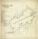
| Description: | Map is ink on tracing paper. The left margin has an index of archeological sites around Koshkonong Lake. Lake Koshkonong is labelled. |
| Date: | 1940 |
|---|---|
| Description: | This map of Watertown pictorially shows historic buildings, locations, and events with dates. The map is printed in brown ink with the border printed in gr... |

| Date: | 1940 |
|---|---|
| Description: | This map of Aztalan is pencil and ink on paper. The map shows streets, local businesses, churches, houses, and the Crawfish River. The map reads: "Informat... |

| Date: | 1887 |
|---|---|
| Description: | This map shows landownership, lot and block numbers, wards, cemeteries, and the high school. The map has been removed from Page’s Atlas of Jefferson County... |

| Date: | 1941 |
|---|---|
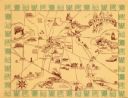
| Description: | This map is ink and watercolor on cardboard and shows Native American legends and villages pictorially. Trails are also shown. |

| Date: | 06 1959 |
|---|---|
| Description: | This blue line print map shows lot and block numbers and dimensions, fair grounds, schools, court house, parks, and the street numbering system. The Crawfi... |

| Date: | 1857 |
|---|---|
| Description: | This map shows lot and block numbers, buildings, some land ownership, wards, waterways, streets, railroads, brick yards, and cemeteries. It includes an ind... |

| Date: | 04 1901 |
|---|---|
| Description: | A Sanborn map of Watertown, including an index and a key. |

| Date: | 10 1884 |
|---|---|
| Description: | A Sanborn map of Watertown, including the City Brewery and the Rock River. |
If you didn't find the material you searched for, our Library Reference Staff can help.
Call our reference desk at 608-264-6535 or email us at: