 Filter: Categories of Wisconsin Historical Images
Filter: County of Iron
Filter: Subject of church buildings
Filter: Categories of Wisconsin Historical Images
Filter: County of Iron
Filter: Subject of church buildings
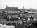
| Date: | 07 15 1906 |
|---|---|
| Description: | Elevated view from the south of a crowd gathered to witness and celebrate the laying of the cornerstone of the new St. Mary of the Seven Dolors Catholic Ch... |

| Date: | 1896 |
|---|---|
| Description: | A map of Iron County, Wisconsin, shows vacant Wisconsin Central Rail Road lands, settlers houses, land sold by Wisconsin Central R.R., schools, churches, s... |

| Date: | 1898 |
|---|---|
| Description: | A map of Iron County, Wisconsin, shows vacant Wisconsin Central Rail Road lands, settlers houses, land sold by Wisconsin Central R.R., schools, churches, s... |

| Date: | |
|---|---|
| Description: | A map that shows the Wisconsin Central Railway land grant lands for sale by the Soo Line, the Chicago, Milwaukee, and St. Paul Railway. Town sections, lak... |

| Date: | 1909 |
|---|---|
| Description: | This map covers Iron and Price Counties and portions of Sawyer and Oneida Counties. The map shows vacant and sold Wis. Central Ry. land, settlers houses, s... |

| Date: | 1907 |
|---|---|
| Description: | Elevated view of Hurley, WI and nearby industrial sites (Scott & Howe Lumber Co. Mill, Ashland Mine). Inventory reads: "Looking west and a little south ove... |
If you didn't find the material you searched for, our Library Reference Staff can help.
Call our reference desk at 608-264-6535 or email us at: