Filter: Categories of Wisconsin Historical Images
Filter: County of Iowa
Filter: Year of 1800-1899
Filter: Year of 1830-1839
Filter: Categories of Wisconsin Historical Images
Filter: County of Iowa
Filter: Year of 1800-1899
Filter: Year of 1830-1839
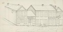
| Date: | 1838 |
|---|---|
| Description: | Pencil sketch of a building owned by the Rodolf family along a commercial street. |
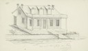
| Date: | 1838 |
|---|---|
| Description: | Pencil sketch of a stone house with a porch the full length of the dwelling, supported by 6 columns. |
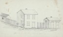
| Date: | 1838 |
|---|---|
| Description: | Pencil sketch of buildings, including the Post Office. |
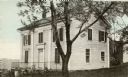
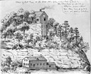
| Date: | 1838 |
|---|---|
| Description: | The Odd Fellows Hall, built in 1837-1838, was the first to be built west of the Allegheny Mountains. The cornerstones were laid by Thomas Widley. |
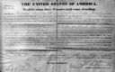
| Date: | 1839 |
|---|---|
| Description: | The deed is for sale of land under jurisdiction of Mineral Point Office in 1839 during the Van Buren administration. Frederick Sprague is from Oakland Coun... |

| Date: | 07 02 1836 |
|---|---|
| Description: | An ink on paper, hand-drawn map shows the sections and streams in Township 5, Range 1 east, which covers parts of the present-day towns of Mifflin and Lind... |

| Date: | 1836 |
|---|---|
| Description: | This early to mid-19th century map shows the township and range system, sections, landownership, furnaces, lead mines, copper mines, and roads in the vicin... |

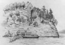
| Date: | 1832 |
|---|---|
| Description: | This map shows lot and block numbers, as well as the location of a shot tower, houses, stores, and barns. The map is oriented with the north to the left. T... |
If you didn't find the material you searched for, our Library Reference Staff can help.
Call our reference desk at 608-264-6535 or email us at: