 Filter: Categories of Wisconsin Historical Images
Filter: County of Iowa
Filter: Year of 1800-1899
Filter: Categories of Wisconsin Historical Images
Filter: County of Iowa
Filter: Year of 1800-1899
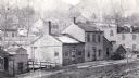
| Date: | 1868 |
|---|---|
| Description: | Mineral Point from a carte-de-visite by the "practical photographer." |
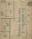
| Date: | 08 1884 |
|---|---|
| Description: | Sheet 1 of a Sanborn map of a portion of Mineral Point. |

| Date: | 08 1884 |
|---|---|
| Description: | Sheet 2 of a Sanborn map of a portion of Mineral Point. |

| Date: | 04 1889 |
|---|---|
| Description: | Sheet 1 of a Sanborn map of a portion of Mineral Point. |

| Date: | 04 1889 |
|---|---|
| Description: | Sheet 2 of a Sanborn map of a portion of Mineral Point. |

| Date: | 04 1889 |
|---|---|
| Description: | Sheet 4 of a Sanborn map of a portion of Mineral Point. |

| Date: | 07 1894 |
|---|---|
| Description: | Sheet 5 of a Sanborn map of a portion of Mineral Point. |
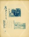
| Date: | 1895 |
|---|---|
| Description: | Page showing the month of April from the Hillside Home School calendar. Included are two small cyanotype photographs, one of a house and the other of a fie... |

| Date: | 1895 |
|---|---|
| Description: | Group portrait of members of the Greene, Shepard, Gadlin, Grimes, and Craig families who lived in the Pleasant Ridge community. |
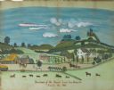
| Date: | 1881 |
|---|---|
| Description: | Watercolor painting of farm and farmhouse, residence of Mr. Daniel Lewis. |
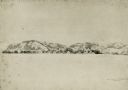
| Date: | 08 1852 |
|---|---|
| Description: | Pencil drawing of Rattlesnake Bluff and the town of Arena from a distance across a plain. A row of buildings runs along the foot of the gently rolling hill... |
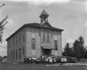
| Date: | 1882 |
|---|---|
| Description: | Teachers and students pose in front of the public school. |
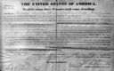
| Date: | 1839 |
|---|---|
| Description: | The deed is for sale of land under jurisdiction of Mineral Point Office in 1839 during the Van Buren administration. Frederick Sprague is from Oakland Coun... |

| Date: | 07 02 1836 |
|---|---|
| Description: | An ink on paper, hand-drawn map shows the sections and streams in Township 5, Range 1 east, which covers parts of the present-day towns of Mifflin and Lind... |

| Date: | 1870 |
|---|---|
| Description: | A map of Iowa County, Wisconsin mounted on cloth that shows the villages of Avoca, Mifflin, Linden, Arena, Helena Station, Highland, Dodgeville, as well as... |

| Date: | 1836 |
|---|---|
| Description: | This early to mid-19th century map shows the township and range system, sections, landownership, furnaces, lead mines, copper mines, and roads in the vicin... |

| Date: | 1847 |
|---|---|
| Description: | Shows parts of northeastern Iowa County, northwestern Dane County, and the extreme southern part of Sauk County "shewing the position of the British Temper... |

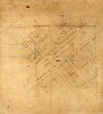
| Date: | 1832 |
|---|---|
| Description: | This map shows lot and block numbers, as well as the location of a shot tower, houses, stores, and barns. The map is oriented with the north to the left. T... |

| Date: | 1840 |
|---|---|
| Description: | This map shows local streets, numbered lots, and part of Blue Mounds Branch. The map reads: "NE 1/4 NW 1/4 Sect. 16 - T5 - R5E." under the title and is dat... |
| Date: | 1800 |
|---|---|
| Description: | This map is pencil and ink on tracing cloth. The map shows plat of the town and local streets. There are some manuscript annotations in pencil and red ink. |
If you didn't find the material you searched for, our Library Reference Staff can help.
Call our reference desk at 608-264-6535 or email us at: