 Filter: Categories of Wisconsin Historical Images
Filter: County of Iowa
Filter: Subject of transportation
Filter: Categories of Wisconsin Historical Images
Filter: County of Iowa
Filter: Subject of transportation
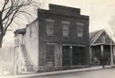
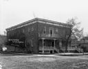
| Date: | 1932 |
|---|---|
| Description: | View from across street of the Washburn and Woodman Bank building, erected by C.C. Washburn and Cyrus Woodman. The bank was established in 1846 and operate... |
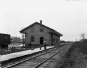
| Date: | 1925 |
|---|---|
| Description: | Railroad depot taken as part of a survey by the Wisconsin Power and Light Company to promote economic development by emphasizing available buildings and bu... |
| Date: | 1913 |
|---|---|
| Description: | Exterior of Taliesin designed by architect Frank Lloyd Wright. Taliesin is located in the vicinity of Spring Green. |
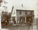
| Date: | |
|---|---|
| Description: | John Lloyd Jones house, near Hillside Home School on Highway 23 across from Taliesin. A man and a woman are standing and holding bicycles, one woman is kne... |
| Date: | 1909 |
|---|---|
| Description: | Exterior view of the front and side of the Wisconsin House. |
| Date: | 1909 |
|---|---|
| Description: | View across railroad tracks of a man and a dog posing on the platform in front of the Chicago, Milwaukee, and St. Paul depot. In the background on the left... |
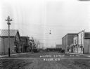
| Date: | 1921 |
|---|---|
| Description: | View down middle of main street of the business district. Automobiles are parked along the curb and pedestrians are on the sidewalk. |
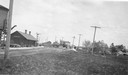
| Date: | 1909 |
|---|---|
| Description: | View down the main dirt road of the business district. |

| Date: | 1959 |
|---|---|
| Description: | Panoramic view of the funeral procession of architect Frank Lloyd Wright, with Taliesin seen in the center background. Following the farm wagon hearse are ... |
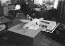
| Date: | 1926 |
|---|---|
| Description: | Architectural model of a village-type gasoline station designed by Frank Lloyd Wright on display at Taliesin. Taliesin is located in the vicinity of Spring... |
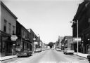
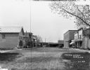
| Date: | 1960 |
|---|---|
| Description: | View of businesses on High Street, including the Rexall Drugstore on the left corner. One can also see a glimpse of the City Hall, directly across the stre... |
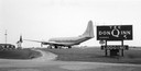
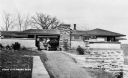
| Date: | |
|---|---|
| Description: | An airplane at the thematically-based Don Q Inn. |
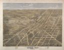
| Date: | 1875 |
|---|---|
| Description: | Bird's-eye map of Dodgeville, looking east, with insets of the high school and county courthouse. |
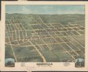
| Date: | 1872 |
|---|---|
| Description: | Bird's-eye map of Mineral Point, looking southeast. |

| Date: | 1890 |
|---|---|
| Description: | View looking down railroad tracks towards the Chicago, Milwaukee and St. Paul Railroad locomotive #240, a type 4-4-0. On the right is a steep, rocky bank, ... |
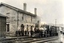
| Date: | 1890 |
|---|---|
| Description: | Chicago, Milwaukee and St. Paul Railroad locomotive #280 at the Mineral Point depot. A group of people stand on the platform. The depot was built in 1857, ... |
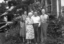
| Date: | 07 30 1946 |
|---|---|
| Description: | Helene Stratman-Thomas, right, Moody Price and three other people. |

| Date: | 1840 |
|---|---|
| Description: | A hand-drawn plat map of Mineral Point, Wisconsin showing street layout and location of buildings. |
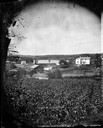
| Date: | 1875 |
|---|---|
| Description: | View, through a cornfield, of people, a store, a sawmill and wagons. Moscow was platted in 1850 by an Englishman, Chauncy Smith, who dammed the Bluemound ... |
If you didn't find the material you searched for, our Library Reference Staff can help.
Call our reference desk at 608-264-6535 or email us at:
