 Filter: Categories of Wisconsin Historical Images
Filter: County of Iowa
Filter: Type of Map or Atlas
Filter: Subject of intellectual life
Filter: Categories of Wisconsin Historical Images
Filter: County of Iowa
Filter: Type of Map or Atlas
Filter: Subject of intellectual life
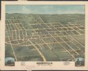
| Date: | 1875 |
|---|---|
| Description: | Bird's-eye map of Dodgeville, looking east, with insets of the high school and county courthouse. |
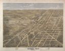
| Date: | 1872 |
|---|---|
| Description: | Bird's-eye map of Mineral Point, looking southeast. |

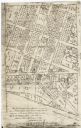
| Date: | 1850 |
|---|---|
| Description: | Lithograph of a map drawn to indicate a mine on land owned by Mineral Point Mining Co. in the lead region of southwestern Wisconsin. |

| Date: | |
|---|---|
| Description: | A hand-colored geological cross section of Iowa County and eastern Dane County, Wisconsin, from the Blue Mounds north-northwest to the sandy plain of the W... |
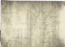
| Date: | 1900 |
|---|---|
| Description: | This facsimile of manuscript map shows lot numbers, dimensions, streets, and township lines. The bottom left corner includes a certification. |
| Date: | 1900 |
|---|---|
| Description: | This facsimile of a manuscript map shows lots and streets. The lower left corner includes a certification. |
If you didn't find the material you searched for, our Library Reference Staff can help.
Call our reference desk at 608-264-6535 or email us at: