 Filter: Categories of Wisconsin Historical Images
Filter: County of Green Lake
Filter: Subject of lakes
Filter: Categories of Wisconsin Historical Images
Filter: County of Green Lake
Filter: Subject of lakes
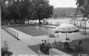
| Date: | 1940 |
|---|---|
| Description: | View towards swimming pool towards people relaxing and sitting around the pool near the lake at the Baptist Assembly Grounds. Caption reads: "The Pool Nort... |
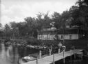
| Date: | |
|---|---|
| Description: | Rear view of the Bible Institute on Green Lake. Two men are sitting in a boat docked at a pier. Behind them are stairs leading to the rear entrance of the ... |

| Date: | |
|---|---|
| Description: | View of a swimming pool at Lawsonia Country Club, which opened to the public in 1930. Two diving boards are in the foreground at one end of the pool. Table... |

| Date: | |
|---|---|
| Description: | Exterior view along shoreline toward the Lawsonia Country Club Hotel, which opened to the public in 1930. Outside the building, stairs lead to the shore of... |

| Date: | 1913 |
|---|---|
| Description: | Ink and watercolor on tracing cloth. Shows parts of Green Lake, Princeton, and Brooklyn townships, Indian mound groups, Green Lake, and other significant b... |

| Date: | |
|---|---|
| Description: | Black and white postcard of a view across water towards the Roger Williams Inn (now the Green Lake Conference Center), main building of the American Baptis... |

| Date: | 1917 |
|---|---|
| Description: | View of sandstone cliffs on the shore of Green Lake. Caption reads: "Wave-worn Rocks at Sandstone, Green Lake, Wis." |

| Date: | 1857 |
|---|---|
| Description: | Green Lake County plat map, T. 15 N., R. 12 E. |

| Date: | 1857 |
|---|---|
| Description: | Green Lake County plat map, T. 16 N, R. 12 E. |

| Date: | 1857 |
|---|---|
| Description: | Green Lake County plat map, T. 14 N, R. 13 E. |

| Date: | 1857 |
|---|---|
| Description: | Green Lake County plat map, T. 15 N, R. 13 E. |
If you didn't find the material you searched for, our Library Reference Staff can help.
Call our reference desk at 608-264-6535 or email us at: