 Filter: Categories of Wisconsin Historical Images
Filter: County of Green
Filter: Subject of pedestrians
Filter: Categories of Wisconsin Historical Images
Filter: County of Green
Filter: Subject of pedestrians

| Date: | 1860 |
|---|---|
| Description: | Bird's-eye drawing of New Glarus. |
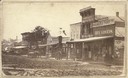
| Date: | 1870 |
|---|---|
| Description: | West side view of the Courthouse Square, with Hassinger & Chandler Dry Goods in the foreground. |

| Date: | 1910 |
|---|---|
| Description: | View of St. John's Evangelical Church in Monroe. |
| Date: | 04 1925 |
|---|---|
| Description: | A church is in the distance at the end of the road. On either side of the street are homes and stores, with a street light suspended above the street in t... |
| Date: | 1924 |
|---|---|
| Description: | View down road lined with trees and storefronts. A number of automobiles can be seen parked. The Post Office is on the right. |

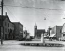
| Date: | 1925 |
|---|---|
| Description: | View down Main Street of the central business district, with many parked automobiles, storefronts, power lines, and sidewalks on both sides of the street. |

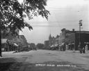
| Date: | 1925 |
|---|---|
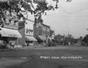
| Description: | View down Main Street of the central business district, with many storefronts. Many automobiles are parked on both sides of the street. Pedestrians are on ... |

| Date: | 1925 |
|---|---|
| Description: | View down Main Street of the central business district. Storefronts are on the right side of the street, and pedestrians are standing on the sidewalk. Auto... |

| Date: | |
|---|---|
| Description: | Colorized postcard of Exchange Square on Main Street. The elevated view shows a drug store on the corner and a bank to the right. Most buildings have awnin... |

| Date: | 1917 |
|---|---|
| Description: | View down middle of a retail street. Horses and buggies are parked on either side of the street at the curb. The visible shops signs are: Millinery, WallPa... |
| Date: | 1924 |
|---|---|
| Description: | View down middle of street with many shops. Cars are parked at an angle along both sides of the street. A man rides a bicycle across the intersection. The ... |
| Date: | 1926 |
|---|---|
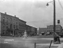
| Description: | A street in the business section of Brodhead. Cars are parked along the curb near storefronts. In the foreground in the middle of the intersection is a str... |
| Date: | 1924 |
|---|---|
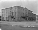
| Description: | View across intersection of the exterior of the Shorb Hotel. Boys on bicycles are in the street in front near a man standing on the curb. Automobiles are p... |

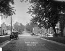
| Date: | |
|---|---|
| Description: | A view down a tree-lined dirt road in a residential area. Houses and sidewalks line both sides of the road, and pedestrians are in the far background. |
| Date: | |
|---|---|
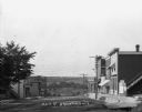
| Description: | A view down Main Street. Shops are on either side of the street. Farmer's Bank is down the hill on the right. |

| Date: | 1929 |
|---|---|
| Description: | View down a street lined with shops and cars. The storefronts include Frank's Place and the Cozy Corner Cafe. |
| Date: | 1925 |
|---|---|
| Description: | View down a commercial street, with Engler's store located on the left. |

| Date: | 1925 |
|---|---|
| Description: | View from a pedestrian walkway looking towards the central business area. A concrete four-sided sign is in the center of intersection. |

| Date: | |
|---|---|
| Description: | Photographic postcard view of an intersection with commercial buildings on both corners. Several horses and carts are on the street, and a windmill is in t... |
If you didn't find the material you searched for, our Library Reference Staff can help.
Call our reference desk at 608-264-6535 or email us at: