Filter: Categories of Wisconsin Historical Images
Filter: County of Green
Filter: Subject of human settlements
Filter: Categories of Wisconsin Historical Images
Filter: County of Green
Filter: Subject of human settlements

| Date: | |
|---|---|
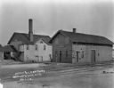
| Description: | Elevated view of Browntown. In the foreground are farm buildings. |
| Date: | |
|---|---|
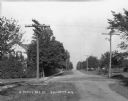
| Description: | A view down an unpaved road lined with utility poles. On the left is a sidewalk and a house partially hidden by trees. |

| Date: | |
|---|---|
| Description: | View from across street of the Farmer's Bank building on a corner. Behind the bank building are wood buildings, one of which has a sign that says, in part,... |
| Date: | |
|---|---|
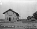
| Description: | The Browntown train depot. The depot offers Wells Fargo & Company Express delivery and Western Union telegraph service. There are two carts on the platform... |

| Date: | |
|---|---|
| Description: | View from shoreline of railroad bridge across a river. Two girls and a boy are standing on the opposite side of the river near the shoreline. |

| Date: | |
|---|---|
| Description: | A group of men and boys pose by a pond. A boy holds a long, probably bamboo, fishing rod. Two men jokingly pose as if they are dancing the tango. |
| Date: | |
|---|---|
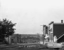
| Description: | A view down Main Street. Shops are on either side of the street. Farmer's Bank is down the hill on the right. |

| Date: | 1861 |
|---|---|
| Description: | Shows townships and sections, landowners, and woodlands. Includes inset maps of Monroe, Brodhead, Albany, Cadiz, Decatur, Dayton, Clarence, Springfield, Tw... |
| Date: | |
|---|---|
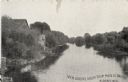
| Description: | Elevated view of Sugar River. The banks are mainly lined with trees. There are houses and other wooden structures along the east bank. Caption reads: "View... |

| Date: | 1929 |
|---|---|
| Description: | View down a street lined with shops and cars. The storefronts include Frank's Place and the Cozy Corner Cafe. |

| Date: | 1909 |
|---|---|
| Description: | View down Main Street of cars and shops lining both sides of the street. The buildings include: the Grand Central Hotel, an ice cream shop, and an automoti... |

| Date: | 1926 |
|---|---|
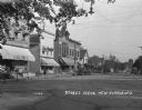
| Description: | View down Main Street. Shops and parked cars line the street. On the near left, there is a billboard for Granger rough cut tobacco, and there is a barbers... |
| Date: | 1925 |
|---|---|
| Description: | View down a commercial street, with Engler's store located on the left. |

| Date: | 1925 |
|---|---|
| Description: | View from a pedestrian walkway looking towards the central business area. A concrete four-sided sign is in the center of intersection. |

| Date: | 1926 |
|---|---|
| Description: | View across street of the exterior of the Bank of New Glarus on the corner of the street. |

| Date: | 1925 |
|---|---|
| Description: | Exterior across lawn of the three-story New Glarus high school. The school building features a decommissioned Civil War cannon near the entrance. |

| Date: | 1925 |
|---|---|
| Description: | View down the road leading to the PET evaporated milk factory. A painted sign on the factory's exterior wall claims PET evaporated milk is "milk at its bes... |
If you didn't find the material you searched for, our Library Reference Staff can help.
Call our reference desk at 608-264-6535 or email us at: