 Filter: Categories of Wisconsin Historical Images
Filter: County of Green
Filter: Subject of architecture
Filter: Categories of Wisconsin Historical Images
Filter: County of Green
Filter: Subject of architecture
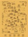
| Date: | 1970 |
|---|---|
| Description: | This pictorial map shows illustrations of historical landmarks and events, some of which include the fairgrounds, churches, the courthouse, Turner Opera Ho... |

| Date: | 1857 |
|---|---|
| Description: | This map shows rural landownership and acreages, lot and block numbers, selected buildings, roads, railroads, and public squares. The map is indexed for th... |

| Date: | 10 16 1916 |
|---|---|
| Description: | Elevated view over crowd of the Cheese Float sponsored by First National Bank in the Monroe Cheese Day parade. On the other side of the streeet are storefr... |

| Date: | |
|---|---|
| Description: | Lobby of the Eugene Hotel. The hotel was located on the southwest corner of the square. |

| Date: | |
|---|---|
| Description: | A room at the Eugene Hotel, with a bed, dresser, tables, luggage rack, chairs, lamps and a telephone. There is a sink in the corner of the room. The hotel ... |

| Date: | |
|---|---|
| Description: | Four young women wearing dresses are posing while sitting on the hood of an automobile parked at the curb in front (south side) of the Eugene Hotel. A boy ... |
| Date: | |
|---|---|
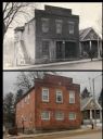
| Description: | A vintage and a modern view of the Washburn and Woodman Bank building, presented as a pair. The modern view was created by Tim Radl. The creator of the vin... |
| Date: | |
|---|---|
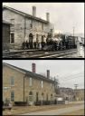
| Description: | A vintage view and a modern view of the railroad depot building in Mineral Point. The vintage view shows a locomotive and a group of men. The modern view r... |

| Date: | |
|---|---|
| Description: | A vintage view and a modern view of a stone Methodist Episcopal Church, which was dedicated in 1871. |

| Date: | |
|---|---|
| Description: | A vintage view and a modern view of stone buildings on Shake Rag Street, presented as a pair. In the vintage view, the buildings were the homes of coal min... |

| Date: | |
|---|---|
| Description: | A vintage and a modern view of the house of Moses Strong, presented as a pair. |

| Date: | |
|---|---|
| Description: | A vintage view and a modern view of Trinity Church, presented as a pair. The church has tall windows and is surrounded by trees. |

| Date: | |
|---|---|
| Description: | A vintage view of the Walker Hotel and a modern view of the Walker House in the same building, presented as a pair. The stone building has a second-story p... |
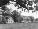
| Date: | 1935 |
|---|---|
| Description: | Large branches of an oak tree frame the view of a large farmhouse, barn, and outbuildings. The two-story house has two front dormers and porches on the fro... |

| Date: | 1908 |
|---|---|
| Description: | Elevated view of buildings, dwellings and churches. Caption reads: "View of Juda, Wis." |

| Date: | 1914 |
|---|---|
| Description: | View of a large corner church with two steeples. Caption reads: "Evangelical Church, Juda, Wis." |

| Date: | 07 1936 |
|---|---|
| Description: | View across harvested field shocks of grain towards the long, two-story brick Carl Marty & Co. factory, featuring a large smokestack and a water tower. The... |
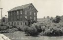
| Date: | 1950 |
|---|---|
| Description: | View across water towards the Historic Monticello Woolen Mill. There are many windows on the mill building, and some of them are open. Other buildings are ... |
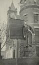
| Date: | 1917 |
|---|---|
| Description: | A sign outside a building reads "Slackers" and includes a list of names: David Englehardt of Browntown, and John Hoffmeister of Jords. The sign is credited... |

| Date: | 1908 |
|---|---|
| Description: | A Sanborn fire map of Brodhead. Includes an inset at top right showing distances from P.O. |
If you didn't find the material you searched for, our Library Reference Staff can help.
Call our reference desk at 608-264-6535 or email us at: