Filter: Categories of Wisconsin Historical Images
Filter: County of Green
Filter: Subject of architecture
Filter: Categories of Wisconsin Historical Images
Filter: County of Green
Filter: Subject of architecture

| Date: | |
|---|---|
| Description: | View down a snowy commercial street. At the corner is the dentist office of Doctor Devereaux on an upper floor. On the left in the far background is a sign... |

| Date: | |
|---|---|
| Description: | View across street of a storefront at a snowy intersection. |

| Date: | |
|---|---|
| Description: | The high school building erected in 1908. The building features three stories, a bell tower, and a hip roof. A small child stands in front of the building. |

| Date: | |
|---|---|
| Description: | Elevated view of Browntown. In the foreground are farm buildings. |

| Date: | |
|---|---|
| Description: | View from across street of the Farmer's Bank building on a corner. Behind the bank building are wood buildings, one of which has a sign that says, in part,... |
| Date: | |
|---|---|
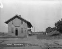
| Description: | The Browntown train depot. The depot offers Wells Fargo & Company Express delivery and Western Union telegraph service. There are two carts on the platform... |

| Date: | |
|---|---|
| Description: | View across road of the exterior of the church. The church features a bell tower, double doors, and lancet windows. Next door, there are two houses. One ha... |
| Date: | |
|---|---|
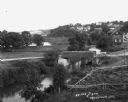
| Description: | Elevated view of a stream with a dam and a bridge. There is a small fenced garden along the water. In the distance is a hillside with houses. |
| Date: | |
|---|---|
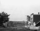
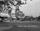
| Description: | A view down Main Street. Shops are on either side of the street. Farmer's Bank is down the hill on the right. |

| Date: | 1861 |
|---|---|
| Description: | Shows townships and sections, landowners, and woodlands. Includes inset maps of Monroe, Brodhead, Albany, Cadiz, Decatur, Dayton, Clarence, Springfield, Tw... |

| Date: | 1909 |
|---|---|
| Description: | View down Main Street of cars and shops lining both sides of the street. The buildings include: the Grand Central Hotel, an ice cream shop, and an automoti... |
| Date: | 04 1926 |
|---|---|
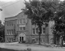
| Description: | View from across road of the exterior of the three-story high school. A datestone above the arched entrance reads: "High School 1913". Caption reads: "High... |
| Date: | 1925 |
|---|---|
| Description: | View down a commercial street, with Engler's store located on the left. |

| Date: | 1925 |
|---|---|
| Description: | View from a pedestrian walkway looking towards the central business area. A concrete four-sided sign is in the center of intersection. |

| Date: | 1926 |
|---|---|
| Description: | View across street of the exterior of the Bank of New Glarus on the corner of the street. |

| Date: | 1925 |
|---|---|
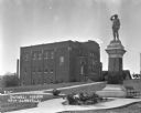
| Description: | Exterior across lawn of the three-story New Glarus high school. The school building features a decommissioned Civil War cannon near the entrance. |

| Date: | 1925 |
|---|---|
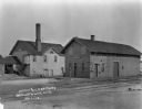
| Description: | View down the road leading to the PET evaporated milk factory. A painted sign on the factory's exterior wall claims PET evaporated milk is "milk at its bes... |
| Date: | 1925 |
|---|---|
| Description: | Outside the Swingli House, near a memorial for the first New Glarus settlers. |

| Date: | 1925 |
|---|---|
| Description: | View down railroad tracks towards the New Glarus train depot. In the background is a water tower and a windmill. |
If you didn't find the material you searched for, our Library Reference Staff can help.
Call our reference desk at 608-264-6535 or email us at: