 Filter: Categories of Wisconsin Historical Images
Filter: County of Grant
Filter: Subject of cities and towns
Filter: Subject of transportation
Filter: Subject of botany
Filter: Categories of Wisconsin Historical Images
Filter: County of Grant
Filter: Subject of cities and towns
Filter: Subject of transportation
Filter: Subject of botany
| Date: | |
|---|---|
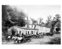
| Description: | Brewery wagons loaded with beer barrels in foreground of the Potosi Brewery. |

| Date: | 1869 |
|---|---|
| Description: | Birds-eye drawing of Boscobel, Grant County, depicts street names and street layouts, houses, rivers and trees. A reference key at the bottom of the map sh... |

| Date: | 1875 |
|---|---|
| Description: | Bird's-eye map of Platteville. |
| Date: | 12 06 1910 |
|---|---|
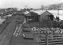
| Description: | Elevated view of stock day at the railroad yards, showing pens of sheep and other livestock ready for loading into railroad cars. All of the cars are deco... |

| Date: | 1829 |
|---|---|
| Description: | Drawing of Cassville depicting a horse cart on the river's edge, with men and boats. |
| Date: | 1973 |
|---|---|
| Description: | Exterior of public school building, with a slide and trees. |

| Date: | 05 1962 |
|---|---|
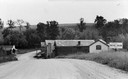
| Description: | Texaco gas station on the left and cars parked on the road next to buildings in downtown Beetown. The road is rutted and muddy with puddles. Several signs ... |
| Date: | 11 01 1896 |
|---|---|
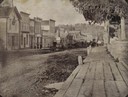
| Description: | Canal Street less than a year before a fire swept through and destroyed many of these buildings on March 22, 1897, resulting in a loss of about $45,000. Pr... |
| Date: | 1880 |
|---|---|
| Description: | Slightly elevated view of street corner, with two buildings that have been destroyed by a fire, a brick fence, and some trees. There is a wooden cart in th... |
| Date: | 1956 |
|---|---|
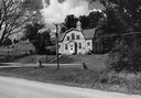
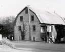
| Description: | The stone building formerly housed the flour mill. The mill was established in 1852, but had pretty well gone out of business by 1895, by which time the po... |

| Date: | 1920 |
|---|---|
| Description: | Bridge over river from shoreline seen through trees in the spring or summer. Part of the bridge is covered. |

| Date: | 1920 |
|---|---|
| Description: | Aerial view of the last covered bridge, which is no longer standing. |
| Date: | 1930 |
|---|---|
| Description: | Street leading down to British Hollow's commercial district. A hill is in the background. |

| Date: | 1900 |
|---|---|
| Description: | Elevated view of the brewery dwarfed by the overhead bluffs. The brewery was built by William Schmitz. George Scheibl ran the brewery from 1899 until his d... |
| Date: | 1900 |
|---|---|
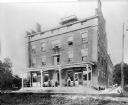
| Description: | Denniston House, P.J. Schnorrenberg, proprietor. View across railroad tracks of the hotel entrance with porch. A man and three women are standing on the po... |
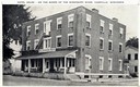
| Date: | 1935 |
|---|---|
| Description: | Caption reads: "Hotel Oelke - on the banks of the Mississippi River, Cassville, Wisconsin." Sign on the hotel reads: "Old Denniston House". This view show... |
| Date: | 1945 |
|---|---|
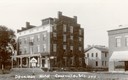
| Description: | The hotel has a sign above the porch that reads: "Old Denniston House". |
| Date: | 1925 |
|---|---|
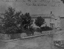
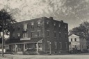
| Description: | View across railroad tracks towards the Denniston House Hotel. |
| Date: | 1900 |
|---|---|
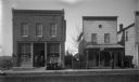
| Description: | View across dirt road of two businesses. On the left is a two-story brick building with large windows which are painted with signs that say: "Habermann Buf... |
| Date: | 1908 |
|---|---|
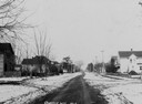
| Description: | Snow-covered residential street with houses on each side. |
If you didn't find the material you searched for, our Library Reference Staff can help.
Call our reference desk at 608-264-6535 or email us at: